Latitude: 51.6696 / 51°40'10"N
Longitude: 0.3832 / 0°22'59"E
OS Eastings: 564901
OS Northings: 199447
OS Grid: TQ649994
Mapcode National: GBR NJW.7QD
Mapcode Global: VHJKD.L9GF
Plus Code: 9F32M99M+R7
Entry Name: The Crown Inn
Listing Date: 29 December 1952
Last Amended: 9 December 1994
Grade: II
Source: Historic England
Source ID: 1279649
English Heritage Legacy ID: 373683
ID on this website: 101279649
Location: Ingatestone, Brentwood, Essex, CM4
County: Essex
District: Brentwood
Civil Parish: Ingatestone and Fryerning
Built-Up Area: Ingatestone
Traditional County: Essex
Lieutenancy Area (Ceremonial County): Essex
Church of England Parish: Ingatestone St Edmund and St Mary
Church of England Diocese: Chelmsford
Tagged with: Inn
INGATESTONE AND FRYERNING
TQ6499 HIGH STREET, Ingatestone
723-1/14/401 (South East side)
29/12/52 The Crown Inn
(Formerly Listed as:
BRENTWOOD
HIGH STREET, Ingatestone (South East side)
(The Crown Inn)
GV II
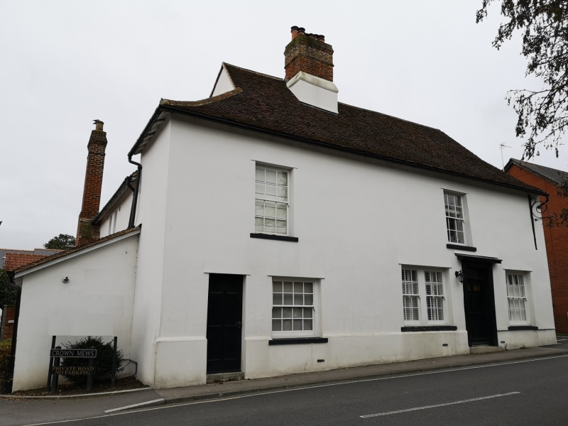
Public house. C15, altered in C19. Timber roofed with handmade red clay tiles. 3-bay main range facing NW with C16 axial stack in left bay, and 3-bay cross-wing to left. External stack to rear of right bay, enclosed by 2-storey lean-to, with C19 single-storey lean-to to rear.
C18/19 2-storey wing to left, completing an almost rectangular plan. External stack to left of rear bay of cross-wing, and single-storey bay of cross-wing, and single-storey lean-to in front of it.
2 storeys. Ground floor, 2 early C19 sashes 6+6 lights, one of 8+8 lights, and reproduction sash of 10+10 lights. First floor, 2 early C19 sashes of 6+6 lights. Early C19 flush 6-panel door and plain overlight in simple doorcase, and one C20 half-glazed door. The stack has an ovolo-moulded brick cornice, and is partly cement-rendered. Roofed as a continuous main range over the lower cross-wing, with 3 gables to the rear. The rear elevation of the middle rear wing is of painted brick to first-floor level, plastered timber-framing above, with one C19 casement. The rear elevation of the cross-wing is jetted, with painted brick below.
INTERIOR: the main stack has a large wood-burning hearth with
0.33m jambs facing to right, and a smaller hearth facing to left. To the rear of it is an original doorway with chamfered jambs and 4-centred arch. The main range has chamfered axial beams, joists plastered to the soffits, an inserted post ~ supporting them, and much reused timber used as decor. The t cross-wing has exposed heavy plain joists of near-square] section jointed to an unchamfered binding beam. This building j is shown in elevation in a map of 1601 by the John Walker, J father and son, as of 2 storeys throughout, with a central door, 4 windows in each storey, 3 gables to the front (of which the middle is a feature gable, smaller than the others) and 2 internal stacks.
(Essex Record Office: D/DP: 8).
Listing NGR: TQ6490199447
External links are from the relevant listing authority and, where applicable, Wikidata. Wikidata IDs may be related buildings as well as this specific building. If you want to add or update a link, you will need to do so by editing the Wikidata entry.


Other nearby listed buildings