Latitude: 52.2314 / 52°13'53"N
Longitude: -1.08 / 1°4'48"W
OS Eastings: 462927
OS Northings: 259648
OS Grid: SP629596
Mapcode National: GBR 9TW.3RF
Mapcode Global: VHCVM.75DQ
Plus Code: 9C4W6WJ9+HX
Entry Name: Former Weedon Barracks, Outer Walls and North East Bastion
Listing Date: 6 August 1982
Last Amended: 29 April 1987
Grade: II*
Source: Historic England
Source ID: 1281700
English Heritage Legacy ID: 360819
ID on this website: 101281700
Location: Weedon Bec, West Northamptonshire, NN7
County: West Northamptonshire
Civil Parish: Weedon Bec
Built-Up Area: Weedon Bec
Traditional County: Northamptonshire
Lieutenancy Area (Ceremonial County): Northamptonshire
Church of England Parish: Weedon Bec St Peter and St Paul
Church of England Diocese: Peterborough
Tagged with: Architectural structure
WEEDEN BEC
1732/16/173 BRIDGE STREET
06-AUG-82 LOWER WEEDON
(West side)
FORMER WEEDON BARRACKS, OUTER WALLS AN
D NORTH EAST BASTION
(Formerly listed as:
BRIDGE STREET
LOWER WEEDON
ENCLOSURE WALLS AND BASTIONS)
GV II*
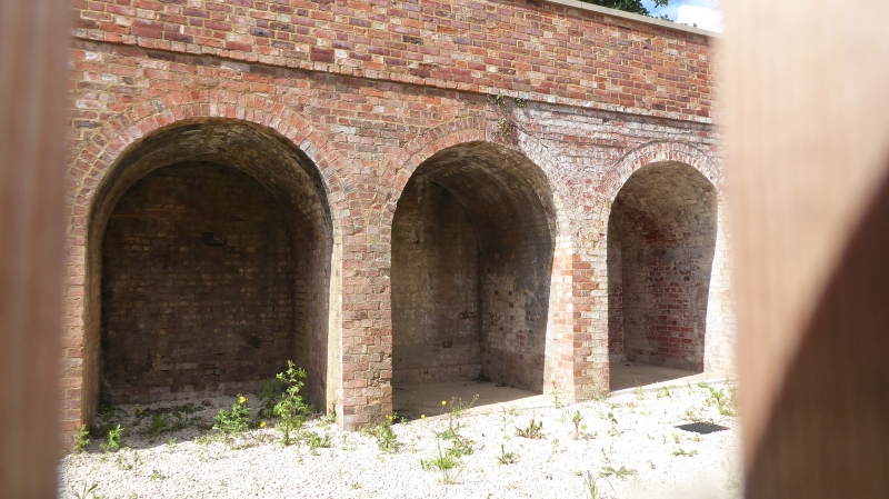
Enclosure walls, gates and gatepiers to north-east bastion, for perimeter security of the site. 1804-10. Red brick in Flemish bond, with stone coping to NE bastion. Ten casemates built in groups of four and six along each side of the angle formed by the corner of the perimeter wall, these including a casemate at each end (probably for storage of artillery pieces) that flank a wall that spans the angle and is pierced by a central segmental-arched entrance. Semi-circular vaults to casemates, which are surmounted by bomb-proof layer of sand and gravel capped by a layer of bricks and finally a stone-flag walkway, which is accessed by ramps with stone-paved stairs and runways for the deployment of small artillery pieces (referred to in 1830 Ordnance Return). One loophole enlarged in late C19, this bastion not being as suited for the defence of the Depot on account of its poor field of fire. Pintle hinges and fittings for doors. C20 gates. Approx. 10m of perimeter wall extends to W, that to S extending to the East lodge (qv): this latter section includes a brick-faced concrete pillbox of 1940, with embrasures for machine guns facing into the main site, brick piers to two sets of entrances (that to N inserted for the site railway of 1899). Other late C19 and C20 extensions along the E enclosure wall are not of special interest.
Part of a unique planned military-industrial complex, complete with its own defensible transport system and surrounding walls. For full details see description of Storehouse No 2.
External links are from the relevant listing authority and, where applicable, Wikidata. Wikidata IDs may be related buildings as well as this specific building. If you want to add or update a link, you will need to do so by editing the Wikidata entry.


Other nearby listed buildings