Approximate Location Map
Large Map »
Latitude: 52.3376 / 52°20'15"N
Longitude: -2.2767 / 2°16'36"W
OS Eastings: 381242
OS Northings: 271088
OS Grid: SO812710
Mapcode National: GBR 0C0.F6S
Mapcode Global: VH920.HH7W
Plus Code: 9C4V8PQF+28
Entry Name: 16 and 17, Lichfield Street
Listing Date: 11 October 1991
Grade: II
Source: Historic England
Source ID: 1292645
English Heritage Legacy ID: 393352
ID on this website: 101292645
Location: Stourport-on-Severn, Wyre Forest, Worcestershire, DY13
County: Worcestershire
District: Wyre Forest
Civil Parish: Stourport-on-Severn
Built-Up Area: Stourport-on-Severn
Traditional County: Worcestershire
Lieutenancy Area (Ceremonial County): Worcestershire
Church of England Parish: Stourport-on-Severn and Wilden
Church of England Diocese: Worcester
Tagged with: Building
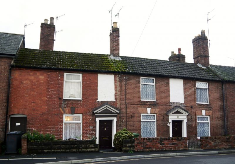
STOURPORT ON SEVERN
SO8171SW LICHFIELD STREET
589-1/9/45 (South side)
Nos.16 AND 17
GV II
Pair of houses, and built as such. c1800. Brick with concrete
tiled roofs. 2-storeyed, No.16 is a single unit plan with
round arched entrance to passage to left, doorway to right,
No.17 has central doorway. Both have fielded panelled doors in
pedimented cases with shouldered architraves and beading.
Windows renewed in original openings, with fine gauged brick
heads with keystones. Blind windows over doorways. Gable end
stacks.
Listing NGR: SO8124271088
External links are from the relevant listing authority and, where applicable, Wikidata. Wikidata IDs may be related buildings as well as this specific building. If you want to add or update a link, you will need to do so by editing the Wikidata entry.


Other nearby listed buildings
