Approximate Location Map
Large Map »
Latitude: 52.3432 / 52°20'35"N
Longitude: -2.2729 / 2°16'22"W
OS Eastings: 381504
OS Northings: 271710
OS Grid: SO815717
Mapcode National: GBR 0C0.25X
Mapcode Global: VH920.KC8L
Plus Code: 9C4V8PVG+7R
Entry Name: Baldwin Memorial in Graveyard, Circa 32 Metres South of Church Ruins
Listing Date: 11 October 1991
Grade: II
Source: Historic England
Source ID: 1292638
English Heritage Legacy ID: 393317
ID on this website: 101292638
Location: St Michael and All Angels Church, Stourport-on-Severn, Wyre Forest, Worcestershire, DY13
County: Worcestershire
District: Wyre Forest
Civil Parish: Stourport-on-Severn
Built-Up Area: Stourport-on-Severn
Traditional County: Worcestershire
Lieutenancy Area (Ceremonial County): Worcestershire
Church of England Parish: Stourport-on-Severn and Wilden
Church of England Diocese: Worcester
Tagged with: Memorial
STOURPORT ON SEVERN
SO8171NW CHURCH AVENUE
589-1/5/13 (North side)
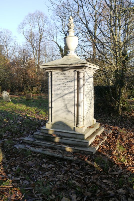
Baldwin Memorial in graveyard, c.32
metres south of church ruins
GV II
Memorial tomb. Probably early C19, but commemorating members
of the Baldwin family between 1795 and 1874. Cast-iron. Square
in plan, raised on a plinth which is itself cast-iron, with
engaged shafts marking the angles and pyramidal cap with
flaming urn as finial. Inscribed on 4 sides in memory of
members of the Baldwin family, in whose foundry it was
probably cast.
Listing NGR: SO8150471710
External links are from the relevant listing authority and, where applicable, Wikidata. Wikidata IDs may be related buildings as well as this specific building. If you want to add or update a link, you will need to do so by editing the Wikidata entry.


Other nearby listed buildings
