Approximate Location Map
Large Map »
Latitude: 52.9278 / 52°55'40"N
Longitude: -3.0624 / 3°3'44"W
OS Eastings: 328681
OS Northings: 337237
OS Grid: SJ286372
Mapcode National: GBR 73.MLLP
Mapcode Global: WH78C.XNXV
Plus Code: 9C4RWWHQ+43
Entry Name: Chirk Viaduct
Listing Date: 2 September 1987
Grade: II*
Source: Historic England
Source ID: 1295219
English Heritage Legacy ID: 255806
ID on this website: 101295219
Location: Chirk Bank, Shropshire, LL14
County: Shropshire
Civil Parish: Weston Rhyn
Traditional County: Shropshire
Lieutenancy Area (Ceremonial County): Shropshire
Church of England Parish: Weston Rhyn St John
Church of England Diocese: Lichfield
WESTON RHYN C.P.
SJ 23 NE
1/93
Chirk Viaduct
GV
II*
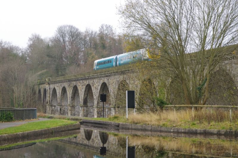
Railway viaduct. 1846-8 by Henry Robertson for the Shrewsbury and Chester Railway with partial rebuilding of 1858-9. Rock-faced ashlar with yellow engineering brick to soffits of central section. Approximately 30 metres high with central section of ten elliptical arches between pedimented abutments and three further arches at each end (1858-9) replacing timber spans. Central arches have pointed voussoirs, projecting keystones and moulded imposts struck through to soffit; modillioned cornice and plain parapet. Abutments have shallow pediments supported on corbelled cornices and round-headed niches with moulded impost bands and projecting moulded keystones. Rock-faced voussoirs to three arches at each end. The viaduct spans the valley of the River Ceiriog and is partly in Wales, the border bisecting the structure at an angle of approximately 45° from south-west to north-east. Forms an impressive sight with the Chirk Aqueduct (q.v.) runnning parallel immediately to east.
This entry was subject to a Minor Amendment on 25 October 2016.
External links are from the relevant listing authority and, where applicable, Wikidata. Wikidata IDs may be related buildings as well as this specific building. If you want to add or update a link, you will need to do so by editing the Wikidata entry.


Other nearby listed buildings
