Approximate Location Map
Large Map »
Latitude: 51.5495 / 51°32'58"N
Longitude: -0.8067 / 0°48'24"W
OS Eastings: 482837
OS Northings: 184080
OS Grid: SU828840
Mapcode National: GBR D61.T04
Mapcode Global: VHDWH.Y9WZ
Plus Code: 9C3XG5XV+R8
Entry Name: Wall to Graveyard at Church of St. Mary and Enclosing Former Priory
Listing Date: 11 April 1972
Last Amended: 22 September 1987
Grade: II
Source: Historic England
Source ID: 1303007
English Heritage Legacy ID: 40919
ID on this website: 101303007
Location: Hurley, Windsor and Maidenhead, Berkshire, SL6
County: Windsor and Maidenhead
Civil Parish: Hurley
Built-Up Area: Hurley
Traditional County: Berkshire
Lieutenancy Area (Ceremonial County): Berkshire
Church of England Parish: Burchetts Green
Church of England Diocese: Oxford
Tagged with: Wall
SU 8284 -8384 HURLEY HIGH STREET
SU 8283-8383 (east side and north side, off)
17/13 18/13. Wall to Graveyard at Church of
St. Mary and enclosing former
Priory (formerly listed as Wall
11.4.72 to Graveyard at Church of St. Mary)
G.V. II
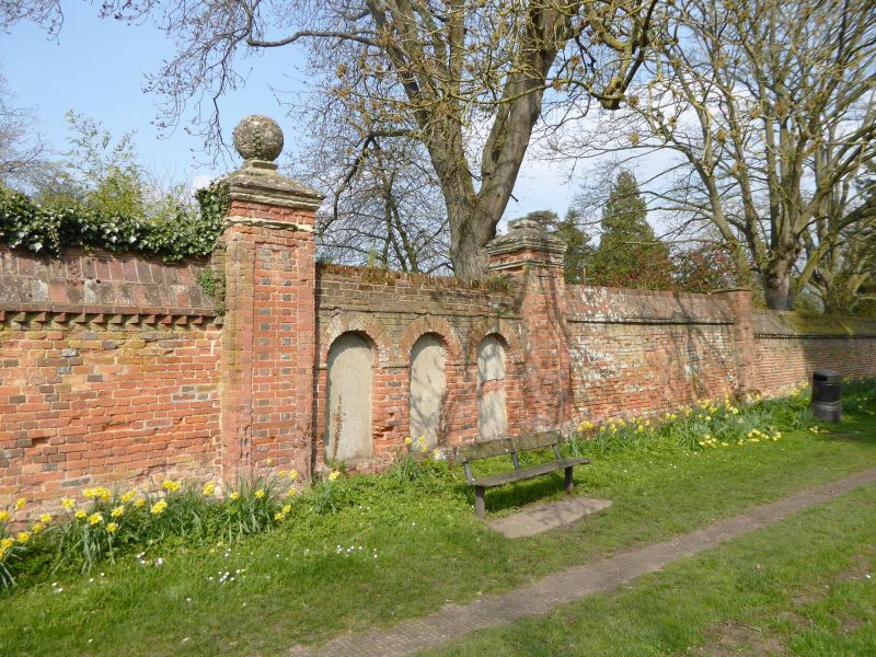
Boundary wall to former priory. C17, C18 and C19. Brick, large ramped weathered
coping. Section on west side of churchyard is C17, about 135 metres long with a
small set-back in mid-length. Section on south side fronting north side of Mill Lane,
about 150 metres long. Part C17, with some C18 and C19 restorations, and mid
C20 openings with curved abutments to Lovelace Close. At the west end there are
3 blocked arched openings, formerly the access to the Church of St. Mary, with a large
C18 pier on each side with moulded stone caps and a ball on finial remaining on the
left one. About 50 metres to the east of these are 3 gate piers, the one on the left
is C19 and the other 2 are C18. All have inset arched panels with stone imposts and
keystone on front face with moulded stone caps surmounted with ball finials. The
opening between the right hand 2 piers has a pair of wrought-iron gates and the smaller
opening on the left one similar gate, all C19. Section on east side: fronting west
side of Mill Lane, about 280 metres long, part C17, parts rebuilt C19, with openings
formed in C20 for access to new properties. On north end the wall turns north west
and links with the bridge (listed separately 17/9) in the grounds of The Refectory.
Section on north side: about 200 metres long. C17, with C18 work. 2 large C18 gate
piers, east of centre, with recessed panels, moulded caps and ball finials, similar to
those piers in the section of the wall on the south side. Replacement iron gates of c1930.
Listing NGR: SU8283784080
External links are from the relevant listing authority and, where applicable, Wikidata. Wikidata IDs may be related buildings as well as this specific building. If you want to add or update a link, you will need to do so by editing the Wikidata entry.


Other nearby listed buildings
