Approximate Location Map
Large Map »
Latitude: 50.2161 / 50°12'57"N
Longitude: -5.477 / 5°28'37"W
OS Eastings: 152045
OS Northings: 40906
OS Grid: SW520409
Mapcode National: GBR DXV3.J12
Mapcode Global: VH12F.0TVQ
Plus Code: 9C2P6G8F+C5
Entry Name: 1-19, Teetotal Street
Listing Date: 22 December 1972
Last Amended: 3 March 1998
Grade: II
Source: Historic England
Source ID: 1312553
English Heritage Legacy ID: 69112
ID on this website: 101312553
Location: St Ives, Cornwall, TR26
County: Cornwall
Civil Parish: St. Ives
Built-Up Area: St Ives
Traditional County: Cornwall
Lieutenancy Area (Ceremonial County): Cornwall
Church of England Parish: St Ives
Church of England Diocese: Truro
Tagged with: Building
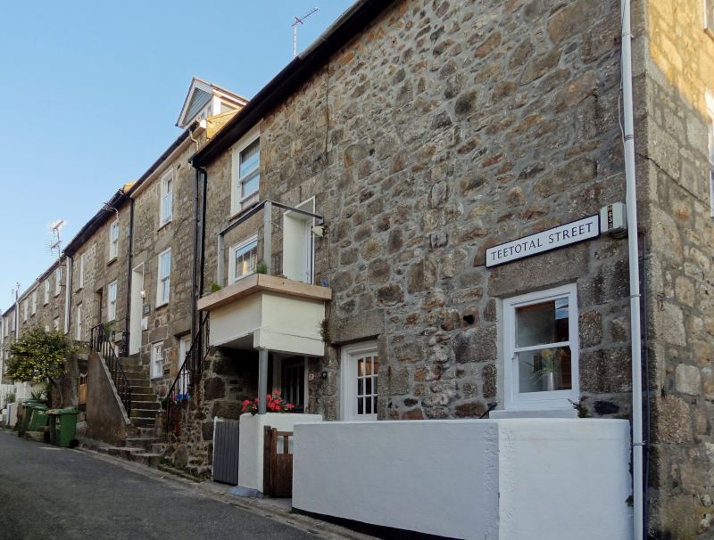
TEETOTAL STREET
---------------
Nos 1 to 19 (consec)
SW 54 SW
678/1/152
22/12/72
GV II
C18/19 terrace. Granite rubble. Three storeys. Two windows each, sashes,
no glazing bars. Some have external steps to first floor entrances. Slate
roofs. No. 19 is on the east end of the terrace. Group value.
Listing NGR: SW5204540906
External links are from the relevant listing authority and, where applicable, Wikidata. Wikidata IDs may be related buildings as well as this specific building. If you want to add or update a link, you will need to do so by editing the Wikidata entry.


Other nearby listed buildings
