Approximate Location Map
Large Map »
Latitude: 51.4539 / 51°27'14"N
Longitude: -0.973 / 0°58'22"W
OS Eastings: 471453
OS Northings: 173271
OS Grid: SU714732
Mapcode National: GBR QLG.J7
Mapcode Global: VHDWT.2QY9
Plus Code: 9C3XF23G+HQ
Entry Name: 7, Gun Street
Listing Date: 14 December 1978
Grade: II
Source: Historic England
Source ID: 1321917
English Heritage Legacy ID: 38964
ID on this website: 101321917
Location: Reading, Berkshire, RG1
County: Reading
Electoral Ward/Division: Abbey
Parish: Non Civil Parish
Built-Up Area: Reading
Traditional County: Berkshire
Lieutenancy Area (Ceremonial County): Berkshire
Church of England Parish: Reading St Mary the Virgin
Church of England Diocese: Oxford
Tagged with: Building
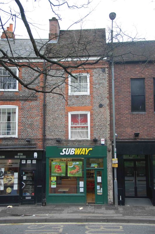
GUN STREET
1.
5128
No 7
SU 7173 SW 2/135
II GV
2.
Late C18 formerly 1 house with Nos 5 and 6 (demolished). Silver grey brick
headers with red dressings. Brick dentil cornice, old tile roof. 1 range
of cross-glazed sash windows to upper floors. Modern shop front on ground
floor with enormous fascia.
Listing NGR: SU7145473270
External links are from the relevant listing authority and, where applicable, Wikidata. Wikidata IDs may be related buildings as well as this specific building. If you want to add or update a link, you will need to do so by editing the Wikidata entry.


Other nearby listed buildings
