Latitude: 51.4541 / 51°27'14"N
Longitude: -0.9726 / 0°58'21"W
OS Eastings: 471483
OS Northings: 173292
OS Grid: SU714732
Mapcode National: GBR QLG.M5
Mapcode Global: VHDWT.3Q54
Plus Code: 9C3XF23G+JX
Entry Name: 13 and 14 Gun Street
Listing Date: 14 December 1978
Last Amended: 19 March 2024
Grade: II
Source: Historic England
Source ID: 1321919
English Heritage Legacy ID: 38969
ID on this website: 101321919
Location: Reading, Berkshire, RG1
County: Reading
Electoral Ward/Division: Abbey
Parish: Non Civil Parish
Built-Up Area: Reading
Traditional County: Berkshire
Lieutenancy Area (Ceremonial County): Berkshire
Church of England Parish: Reading St Mary the Virgin
Church of England Diocese: Oxford
Tagged with: Building
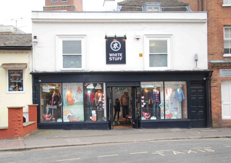
Pair of houses, probably C18, combined by about 1879 and converted to commercial use.
MATERIALS: stuccoed frontage to Gun Street above a timber shopfront. The rear elevation of number 13 (to the west) is rendered. The roof covering is a mixture of plain tile and slate.
The outbuildings to the rear are of red brick laid in Flemish bond with plain-tiled roofs.
PLAN: the building is two storeys high with roofs set behind a parapet. Number 13 (to the west) has an attic storey under a mansard roof. Number 14 (to the east) has a lower, hipped roof. There are two chimney stacks in the party wall between numbers 13 and 14.
EXTERIOR: the ground-floor shopfront has a central recessed doorway with modern glazed doors, flanked by large plate-glass shop windows with slender timber mullions and low stall risers. Console brackets support a narrow projecting cornice over a long fascia board. To the west is a six-panelled door with a painted-over rectangular fanlight.
The first floor has two, one-over-one, timber sash windows with stucco architraves; above is a stucco parapet cornice.
A flat-roofed, two-storey block connects the rear of the buildings to the later outbuildings. The outbuildings are of two storeys under hipped roofs with roof lights.
13 and 14 Gun Street were probably constructed sometime during the C18 as two separate properties. Mapping indicates they had been combined by 1879, and their street frontage was at some point unified with a stucco first floor. They may have been converted to commercial use on the ground floor at this time.
To the rear of each address is a long, two-storey, brick outbuilding linked to the rear of the frontage buildings. These appear to have been extant by 1879 but have since been altered.
The ground and first floors are currently (2021) in commercial use.
The crossroads formed by the north-south route of St Mary’s Butts/Bridge Street and the east-west route of Gun Street/Castle Street is believed to be the centre of the original Saxon settlement at Reading, established sometime before the ninth century. St Mary’s Church, which lies on the north-east corner of the crossroads, was the town’s primary church until the establishment of Reading Abbey in the C12 and became so again following the dissolution in the late 1530s.
Running east from the crossroads, Gun Street forms part of the ancient route through the town between London and the West Country, and the street historically contained many inns and guesthouses. The street is first labelled under its current name on Charles Coates’ map of 1802. The name derives from the gunsmiths who are known to have been operating in Reading from at least the early C17. Most earlier buildings were gradually replaced during the C18 and C19 with townhouses constructed of silver-grey and red brick, following the local vernacular. Many were converted to commercial uses on the ground floors during the C19 or C20.
13 and 14 Gun Street is listed at Grade II for the following principal reasons:
Architectural interest:
* as a C18 building, the fabric of which contributes to Reading’s rich and varied architectural character.
Historic interest:
* as part of the later urban development of Reading’s ancient core.
Group value:
* the building is in close proximity to a number of listed buildings and contributes to a strong historic streetscape.
External links are from the relevant listing authority and, where applicable, Wikidata. Wikidata IDs may be related buildings as well as this specific building. If you want to add or update a link, you will need to do so by editing the Wikidata entry.
Other nearby listed buildings