Approximate Location Map
Large Map »
Latitude: 50.5222 / 50°31'19"N
Longitude: -3.5298 / 3°31'47"W
OS Eastings: 291647
OS Northings: 70277
OS Grid: SX916702
Mapcode National: GBR P1.Q66Y
Mapcode Global: FRA 37HP.8MR
Plus Code: 9C2RGFCC+V3
Entry Name: Chasers
Listing Date: 2 December 1988
Grade: II
Source: Historic England
Source ID: 1333975
English Heritage Legacy ID: 86051
ID on this website: 101333975
Location: Stokeinteignhead, Teignbridge, Devon, TQ12
County: Devon
District: Teignbridge
Civil Parish: Stokeinteignhead
Built-Up Area: Stokeinteignhead
Traditional County: Devon
Lieutenancy Area (Ceremonial County): Devon
Church of England Parish: Stokeinteignhead St Andrew
Church of England Diocese: Exeter
Tagged with: Building Thatched cottage
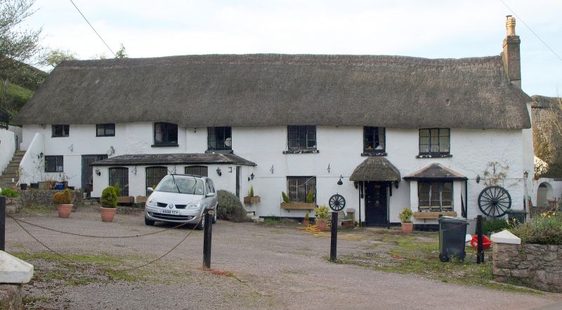
STOKEINTEIGNHEAD STOKE ROAD (west side),
SX 9070-9170 Stokeinteignhead
Chasers
17/408
GV II
House, partly converted to restaurant. Probably C17 or earlier, late C20 alterations.
Whitewashed rendered cob and stone rubble; thatched roof, gabled at right end, hipped
at left end; right end stack, rear lateral stack.
Plan: Single depth plan, possibly originally a 3 room and passage plan arrangement,
but the scale of late C20 interior alteration makes this impossible to prove. The
left end of the range is a converted farmbuilding.
Exterior: 2 storeys. Asymmetrical 2:4 window front (former farmbuilding at left
end). C20 front door to right of centre with a thatched porch at posts, canted bay
window to the right, single storey lean-to addition to the front at the left. 2 and
3-light C19 or C20 timber casement windows. C20 windows to converted farmbuilding at
left end.
Interior: Modernized, with original partitions removed or altered on the ground
floor. Some chamfered crossbeams survive but these are probably C20 replacements.
Roof: Not inspected but may be of interest. In spite of the C20 alterations this
building is important for group value at the end of the village.
Listing NGR: SX9164770277
External links are from the relevant listing authority and, where applicable, Wikidata. Wikidata IDs may be related buildings as well as this specific building. If you want to add or update a link, you will need to do so by editing the Wikidata entry.


Other nearby listed buildings
