Latitude: 52.2472 / 52°14'49"N
Longitude: 0.7218 / 0°43'18"E
OS Eastings: 585905
OS Northings: 264492
OS Grid: TL859644
Mapcode National: GBR QF0.398
Mapcode Global: VHKD4.GSF5
Plus Code: 9F426PWC+VP
Entry Name: 21 and 22, Eastgate Street
Listing Date: 7 August 1952
Last Amended: 30 October 1997
Grade: II
Source: Historic England
Source ID: 1343592
English Heritage Legacy ID: 466808
ID on this website: 101343592
Location: Bury St Edmunds, West Suffolk, IP33
County: Suffolk
District: West Suffolk
Civil Parish: Bury St Edmunds
Built-Up Area: Bury St Edmunds
Traditional County: Suffolk
Lieutenancy Area (Ceremonial County): Suffolk
Church of England Parish: Bury St Edmunds St John the Evangelist
Church of England Diocese: St.Edmundsbury and Ipswich
Tagged with: Building
BURY ST EDMUNDS
TL8564SE EASTGATE STREET 639-1/8/337 (North side) 07/08/52 Nos.21 AND 22 (Formerly Listed as: EASTGATE STREET (North side) Nos.18-22 (Consecutive))
GV II
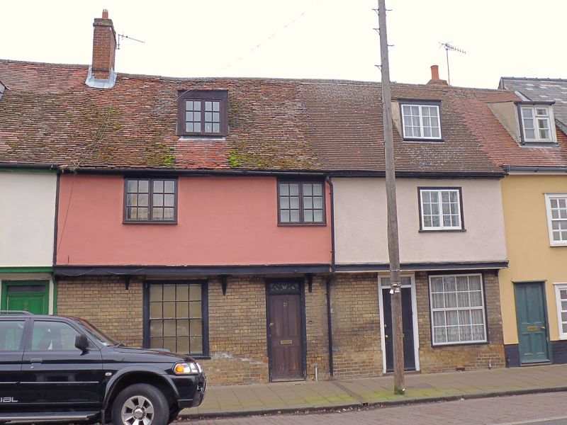
A pair of houses, formerly one house, part now used as offices. Early to mid C16. Timber-framed and rendered on the jettied upper storey, underbuilt in white brick on the ground storey. Plaintiled roof. EXTERIOR: 2 storeys and attics. The ends of the jetty are covered by a fascia board. 3 small-paned 2-light casement windows to the upper storey; 2 sash windows in flush cased frames to the lower storey, 16-pane to No.21, and a C20 larger replacement to No.22. 2 flat-headed dormers with lead-covered roofs and rendered cheeks with 2-light casement windows, at No.22 with small panes. 2 entrance doors with plain wood surrounds and rectangular fanlights. INTERIOR: No.21 in 2 bays. On the ground storey, the main cross-beams are exposed with roll and hollow mouldings.
Listing NGR: TL8590564492
External links are from the relevant listing authority and, where applicable, Wikidata. Wikidata IDs may be related buildings as well as this specific building. If you want to add or update a link, you will need to do so by editing the Wikidata entry.


Other nearby listed buildings