Approximate Location Map
Large Map »
Latitude: 53.1934 / 53°11'36"N
Longitude: -2.8805 / 2°52'49"W
OS Eastings: 341270
OS Northings: 366620
OS Grid: SJ412666
Mapcode National: GBR 7B.2W80
Mapcode Global: WH887.QZJR
Plus Code: 9C5V54V9+9R
Entry Name: Former Steam Flour Mill at SJ 4127 6662
Listing Date: 6 November 1989
Grade: II
Source: Historic England
Source ID: 1375938
English Heritage Legacy ID: 469917
ID on this website: 101375938
Location: Newtown, Cheshire West and Chester, Cheshire, CH3
County: Cheshire West and Chester
Electoral Ward/Division: Boughton
Parish: Non Civil Parish
Built-Up Area: Chester
Traditional County: Cheshire
Lieutenancy Area (Ceremonial County): Cheshire
Church of England Parish: Chester St John the Baptist
Church of England Diocese: Chester
Tagged with: Mill building
CHESTER CITY (EM)
SJ4166 STEAM MILL STREET
1932-1/6/267 (West side)
06/11/89 Former Steam Flour Mill at SJ 4127
6662
GV II
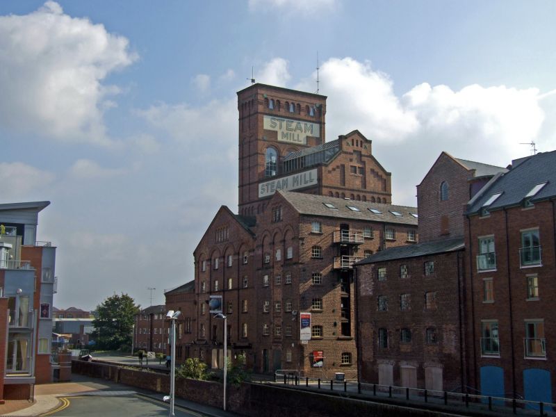
Former steam-powered flour mill, now warehouse and workshop.
c1785 and early and mid C19, with chimney above roof-level,
boilerhouse and engine house since demolished. Brown brick in
irregular English garden wall bond; grey slate roofs.
PLAN/EXTERIOR: erected in 3 phases, the present building is
U-shaped; the middle wing facing Steam Mill Street stands in
the position of the Steam Mill shown on Weston's map of
Chester dated 1789 and incorporates what may be original
cast-iron columns and beams; the 4-storey north wing facing
the Chester Canal is probably early C19; the external features
of the middle and south wings are probably 1840s. The square
internal chimney below roof level survives at the junction of
the middle and south wings. The building is functional with no
applied ornament.
Stone sills and cambered brick window-heads; some openings are
bricked up and a few are altered; those in the middle and
south wings have 36-72 pane cast-iron windows, some with
hoppers of 4-panes and some with inserted casements; a
round-arched window in gable of loft; the north wing has no
sills and replaced 2-pane horizontally-sliding sashes. The
eaves and verges of the north wing are simply corbelled in
brick; the middle and south wings have stone-coped parapet
gables.
INTERIOR: the north wing could not be inspected; the middle
wing is of 4 bays with round cast-iron columns carrying heavy
T-shaped iron beams some with damaged webs; the webs form
shallow triangles, increasing in depth towards the centre of
span. The south wing has large timber beams on inserted
riveted stanchions and a goods lift in a shaft dated 1898. The
external walls are up to 3 feet (1m) thick.
Of prime interest are the very early establishment of a
steam-powered canal-side flour mill and the cast-iron columns
and beams.
(Map of the Loyal City of Chester: Surveyed by Samuel Weston;
Engraved by James Hunter: 1789-; Ordnance Survey Town Map of
Chester: 1875-).
Listing NGR: SJ4127066620
External links are from the relevant listing authority and, where applicable, Wikidata. Wikidata IDs may be related buildings as well as this specific building. If you want to add or update a link, you will need to do so by editing the Wikidata entry.


Other nearby listed buildings
