Latitude: 53.6599 / 53°39'35"N
Longitude: -2.9617 / 2°57'42"W
OS Eastings: 336542
OS Northings: 418585
OS Grid: SD365185
Mapcode National: GBR 7VR3.LR
Mapcode Global: WH862.G8WL
Plus Code: 9C5VM25Q+X8
Entry Name: Hesketh Arms Hotel
Listing Date: 29 September 1951
Grade: II
Source: Historic England
Source ID: 1379549
English Heritage Legacy ID: 478936
ID on this website: 101379549
Location: Churchtown, Sefton, Merseyside, PR9
County: Sefton
Electoral Ward/Division: Meols
Parish: Non Civil Parish
Built-Up Area: Southport
Traditional County: Lancashire
Lieutenancy Area (Ceremonial County): Merseyside
Church of England Parish: North Meols St Cuthbert
Church of England Diocese: Liverpool
Tagged with: Hotel
SOUTHPORT
SD3618NE BOTANIC ROAD, Churchtown
664-1/7/246 (North side)
29/09/51 Hesketh Arms Hotel
GV II
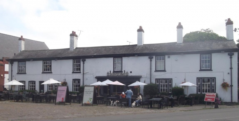
Hotel, now public house. Mid to later C18; enlarged and
altered, and remodelled internally. White painted render on
brick, graduated slate roof with similarly rendered chimneys.
Irregular double-depth plan including main ranges facing west
and south, with additions in angle to rear.
EXTERIOR: the west front of 2 storeys and 6 irregularly
disposed windows, with a moulded gutter cornice and 4 lead
downspouts with large decorated hoppers. Entrance off-set
slightly right of centre remodelled in 1932 as a recessed
3-bay porch with Doric columns; to the left at ground floor 5
segmental-headed windows grouped 2:2:1, and a doorway between
the 2 pairs, and to the right 2 tripartite sashed windows, all
these with glazing bars. The first floor has 6 sashed windows
with raised sills and moulded surrounds, 2 to the left have
4/8 glazing and the others 3/6 glazing. Gable chimneys and 3
ridge chimneys.
The right-hand return (south front) is a 5-window range. C20
doorway, a bow window and 3 small segmental-headed sashes at
ground floor, and 3/6 sashes above.
INTERIOR: retains a good C18 open-string staircase and remains
of some moulded plaster ceiling decoration, but is otherwise
entirely remodelled.
Forms eastern boundary of good group in centre of village,
including Gate piers at south-west corner of Parish Hall, St
Cuthbert's Road (qv), Entrance gateway to Meols Hall to south
(qv), Obelisk (qv) and Old lamp posts on green (qv), Nos 96 &
98 (qv), and Nos 100 & 102 (qv) Botanic Road to south-west,
and Church of St Cuthbert (with associated items), St
Cuthbert's's Road (qv).
Listing NGR: SD3654218585
External links are from the relevant listing authority and, where applicable, Wikidata. Wikidata IDs may be related buildings as well as this specific building. If you want to add or update a link, you will need to do so by editing the Wikidata entry.


Other nearby listed buildings