Latitude: 53.6537 / 53°39'13"N
Longitude: -3.004 / 3°0'14"W
OS Eastings: 333737
OS Northings: 417933
OS Grid: SD337179
Mapcode National: GBR 7VG5.FZ
Mapcode Global: WH861.TFPC
Plus Code: 9C5RMX3W+F9
Entry Name: Lakeside Inn
Listing Date: 29 July 1999
Grade: II
Source: Historic England
Source ID: 1379729
English Heritage Legacy ID: 479134
Also known as: Lakeside Inn, Southport Town Centre, Southport
ID on this website: 101379729
Location: Southport, Sefton, Merseyside, PR9
County: Sefton
Electoral Ward/Division: Cambridge
Parish: Non Civil Parish
Built-Up Area: Southport
Traditional County: Lancashire
Lieutenancy Area (Ceremonial County): Merseyside
Church of England Parish: Southport Holy Trinity
Church of England Diocese: Liverpool
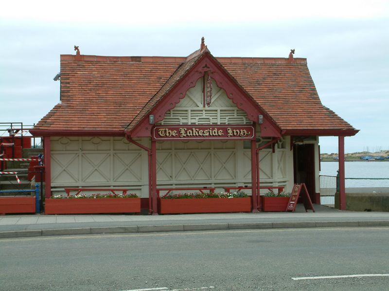
SOUTHPORT
SD3317NE PROMENADE
664-1/9/156 (West side)
Lakeside Inn
GV II
Small public house. Probably built between 1892, when the
north portion of the Marine Lake was added (or 1895, when the
2 lakes were joined) and 1913, when King George V opened the
new lake and gardens.
Timber-framed with panelled boarded walls and red tiled roof
and ridge tiles with a finial near the end of each ridge.
Small rectangular plan, built into north angle between the
Boathouse (which it adjoins) and the Promenade.
EXTERIOR: 2-storey structure presenting only the upper storey
to the Promenade (the lower storey built against the face of
the embankment); 3 bay loggia with wooden posts carrying an
oversailing roof with projected gabled centre, protecting a
small area with benches; pierced bargeboarding to the gable.
Under the loggia the recessed front wall of the enclosed main
range has geometrical framing. The roof is hipped at each end
but with a gable breaking through.
INTERIOR: not inspected.
Forms group with the Boathouse (qv) and with the Cafe on the
lakeside approx. 30m to the south-west (qv).
Listing NGR: SD3373717933
External links are from the relevant listing authority and, where applicable, Wikidata. Wikidata IDs may be related buildings as well as this specific building. If you want to add or update a link, you will need to do so by editing the Wikidata entry.


Other nearby listed buildings