Approximate Location Map
Large Map »
Latitude: 52.5369 / 52°32'12"N
Longitude: -2.8101 / 2°48'36"W
OS Eastings: 345151
OS Northings: 293537
OS Grid: SO451935
Mapcode National: GBR BG.F6VQ
Mapcode Global: VH75V.7HSK
Plus Code: 9C4VG5PQ+QX
Entry Name: 10 and 12, Cunnery Road
Listing Date: 29 February 2000
Grade: II
Source: Historic England
Source ID: 1383281
English Heritage Legacy ID: 483699
ID on this website: 101383281
Location: Worldsend, Shropshire, SY6
County: Shropshire
Civil Parish: Church Stretton
Built-Up Area: Church Stretton
Traditional County: Shropshire
Lieutenancy Area (Ceremonial County): Shropshire
Church of England Parish: Church Stretton
Church of England Diocese: Hereford
Tagged with: Building
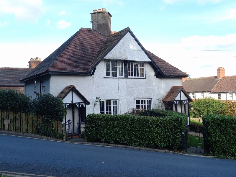
CHURCH STRETTON
SO451935 CUNNERY ROAD
1312-1/13/219 Nos.10 AND 12 (Even)
II
Pair of houses. 1899-1900. By Barry Parker and Raymond Unwin
for Campbell Hyslop.
MATERIALS: colourwashed rendered brick and plain tile hipped
roof with central stack set diagonally.
EXTERIOR: Single storey and attic. House to left has UPVC
windows in original openings, house to right has wooden
casements. A central gable has two 3-light casements set under
the gable above eaves level. 2 similar casements to ground
floor. To left and right a wooden openwork gabled porch with
decorative heads between uprights. Plank doors. Wall ends are
treated as inward sloping buttresses. Small casements on ends
of each house and to rear, where each house has a gable with a
pair of 2-light casements set under the gable.
INTERIOR: not inspected.
HISTORY: this pair of houses is the first built example of
Parker and Unwin's project designs for garden city housing and
as such is the significant precursor for the similar examples
at New Earswick, and developed thera and at Letchworth and
Hampstead Garden Suburb.
Listing NGR: SO4515493537
External links are from the relevant listing authority and, where applicable, Wikidata. Wikidata IDs may be related buildings as well as this specific building. If you want to add or update a link, you will need to do so by editing the Wikidata entry.


Other nearby listed buildings
