Approximate Location Map
Large Map »
Latitude: 52.5368 / 52°32'12"N
Longitude: -2.8089 / 2°48'32"W
OS Eastings: 345229
OS Northings: 293527
OS Grid: SO452935
Mapcode National: GBR BG.F74T
Mapcode Global: VH75V.8HDM
Plus Code: 9C4VG5PR+PC
Entry Name: Ashford House
Listing Date: 15 March 1974
Grade: II
Source: Historic England
Source ID: 1383298
English Heritage Legacy ID: 483716
ID on this website: 101383298
Location: Worldsend, Shropshire, SY6
County: Shropshire
Civil Parish: Church Stretton
Built-Up Area: Church Stretton
Traditional County: Shropshire
Lieutenancy Area (Ceremonial County): Shropshire
Church of England Parish: Church Stretton
Church of England Diocese: Hereford
Tagged with: House
CHURCH STRETTON
SO4593 HIGH STREET
1312-1/13/76 (West side)
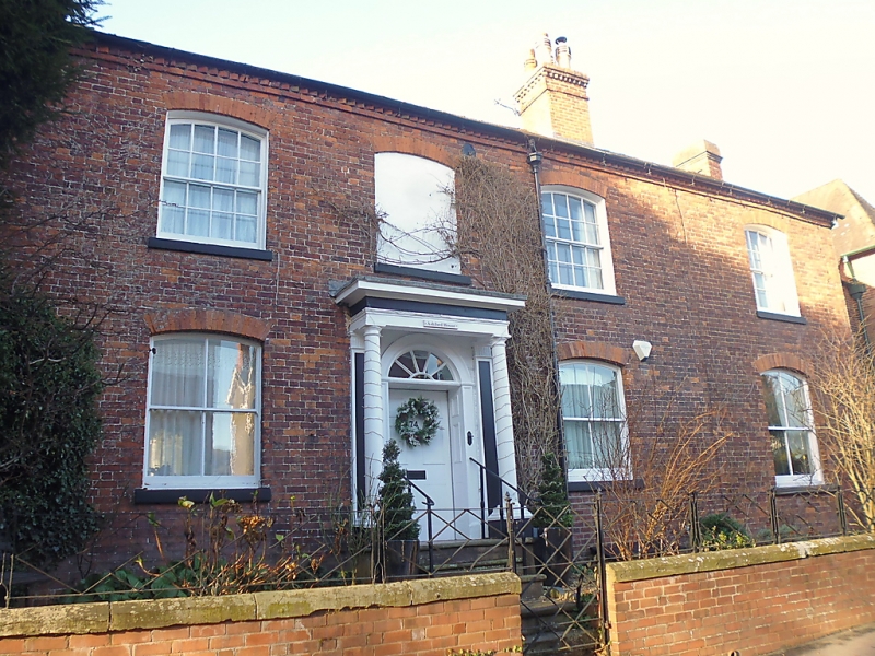
15/03/74 Ashford House
GV II
House. Early C19. Red brick, render. Plain-tile roof with
brick dentil course eaves. Integral brick ridge chimney stack
with dentil oversailing top course and partly projecting
gable-end stack. Rectangular plan parallel to street.
EXTERIOR: street front is a 2-storey, 3-window range of 8/8
sashes with cambered heads and brick segmental-arched lintels
plus one blocked window. Three 2/2 sashes to ground floor
under segmental arches. Moulded wood doorcase with panelled
reveals, fanlight with radial glazing bars and portico with
Tuscan columns, 6-panelled door. Right-hand gable cement
rendered; scalloped bargeboard. 2-storey brick rear wing to
north.
INTERIOR: not inspected.
Listing NGR: SO4522793529
External links are from the relevant listing authority and, where applicable, Wikidata. Wikidata IDs may be related buildings as well as this specific building. If you want to add or update a link, you will need to do so by editing the Wikidata entry.


Other nearby listed buildings
