Approximate Location Map
Large Map »
Latitude: 51.5006 / 51°30'2"N
Longitude: -0.0791 / 0°4'44"W
OS Eastings: 533427
OS Northings: 179707
OS Grid: TQ334797
Mapcode National: GBR VJ.C8
Mapcode Global: VHGR0.LK11
Plus Code: 9C3XGW2C+69
Entry Name: Bonded Warehouse, Sarsons Vinegar Factory
Listing Date: 3 February 1993
Grade: II
Source: Historic England
Source ID: 1385819
English Heritage Legacy ID: 471231
ID on this website: 101385819
Location: Bermondsey, Southwark, London, SE1
County: London
District: Southwark
Electoral Ward/Division: Grange
Parish: Non Civil Parish
Built-Up Area: Southwark
Traditional County: Surrey
Lieutenancy Area (Ceremonial County): Greater London
Church of England Parish: Bermondsey St Mary Magdalen, St Olave, St John and St Luke
Church of England Diocese: Southwark
Tagged with: Bonded warehouse
SOUTHWARK
TQ3379 ROPER LANE
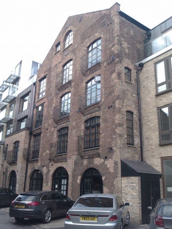
636-1/5/636 Bonded warehouse, Sarson's Vinegar
03/02/93 Factory
GV II
Bonded warehouse. c1825-30. Stock brick in Flemish bond.
4 storeys and attics. Gable fronted with stone coping. Lunette
to gable. 3rd floor has 2 sashes, 1 pivoting. 1st floor has 2
cambered sashes. Ground floor has 2 cambered arches blocked
with later brickwork and doors. Vaulted ceilings to ground
floor.
INTERIOR: not inspected.
Listing NGR: TQ3342779707
External links are from the relevant listing authority and, where applicable, Wikidata. Wikidata IDs may be related buildings as well as this specific building. If you want to add or update a link, you will need to do so by editing the Wikidata entry.


Other nearby listed buildings
