Approximate Location Map
Large Map »
Latitude: 51.5008 / 51°30'2"N
Longitude: -0.0794 / 0°4'45"W
OS Eastings: 533408
OS Northings: 179732
OS Grid: TQ334797
Mapcode National: GBR VJ.95
Mapcode Global: VHGR0.KJXV
Plus Code: 9C3XGW2C+87
Entry Name: Brewhouse, Sarsons Vinegar Factory
Listing Date: 2 August 1993
Grade: II
Source: Historic England
Source ID: 1385820
English Heritage Legacy ID: 471232
ID on this website: 101385820
Location: Bermondsey, Southwark, London, SE1
County: London
District: Southwark
Electoral Ward/Division: Grange
Parish: Non Civil Parish
Built-Up Area: Southwark
Traditional County: Surrey
Lieutenancy Area (Ceremonial County): Greater London
Church of England Parish: Bermondsey St Mary Magdalen, St Olave, St John and St Luke
Church of England Diocese: Southwark
Tagged with: Brewery
SOUTHWARK
TQ3379 ROPER LANE
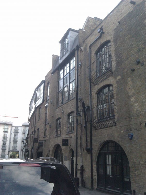
636-1/5/637 Brewhouse, Sarson's Vinegar Factory
02/08/93
GV II
Brewhouse. Mid C19. Stock brick in Flemish bond with mansard
roof covered in corrugated iron sheeting.
3 storeys 2 windows. East front 2nd floor has one triple
window with fixed casements above and pivoting sashes below. 2
cambered windows to 1st floor. Ground floor has round-headed
opening. West front has louvred openings to most windows which
have cambered heads and blocked round-headed opening to
right-hand side.
INTERIOR: not inspected.
Listing NGR: TQ3340879732
External links are from the relevant listing authority and, where applicable, Wikidata. Wikidata IDs may be related buildings as well as this specific building. If you want to add or update a link, you will need to do so by editing the Wikidata entry.


Other nearby listed buildings
