Approximate Location Map
Large Map »
Latitude: 53.4843 / 53°29'3"N
Longitude: -2.2591 / 2°15'32"W
OS Eastings: 382901
OS Northings: 398652
OS Grid: SJ829986
Mapcode National: GBR DFF.JZ
Mapcode Global: WHB9G.8PG7
Plus Code: 9C5VFPMR+P8
Entry Name: Town Hall
Listing Date: 31 January 1952
Grade: II
Source: Historic England
Source ID: 1386076
English Heritage Legacy ID: 471500
ID on this website: 101386076
Location: Salford, Greater Manchester, M3
County: Salford
Electoral Ward/Division: Irwell Riverside
Parish: Non Civil Parish
Built-Up Area: Salford
Traditional County: Lancashire
Lieutenancy Area (Ceremonial County): Greater Manchester
Church of England Parish: Salford St Philip with St Stephen
Church of England Diocese: Manchester
Tagged with: Public building City hall Seat of local government
SALFORD
SJ8298NE BEXLEY SQUARE
949-1/19/3 (North side)
31/01/52 Town Hall
GV II
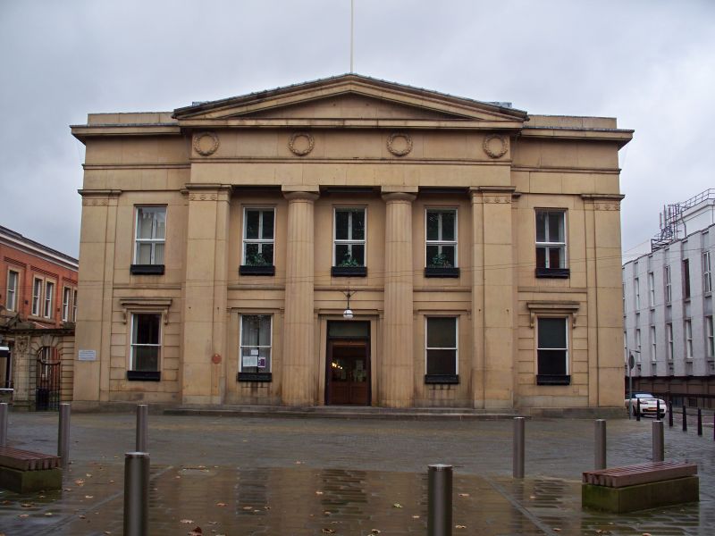
Town hall. 1825-7. Richard Lane. Ashlar-faced, rusticated to
ground floor, and low pitched roof not visible.
EXTERIOR: 2 storeys, 5-window range. Neo-classical style, with
full-height central pedimented section of 3 bays slightly
advanced. Central engaged fluted Doric shafts, and outer
square pilasters supporting entablature with laurel wreath
frieze. Similar pilasters at angles. Central entrance doors
with overlight. 2-pane sash window in each bay, the outer
ground-floor windows with entablatures carried on console
brackets.
Brick return elevations with tripartite sash windows in main
block, then long range divided 4-3-3-9 bays, of varying
heights, but all with stone dressings to sash windows. Central
entrance hall with staircases to sides, then central corridor
running the length of the building. Floor and dado tiling by
Craven Dunnill.
Adjoining the original block to the west, an additional range
of administrative buildings of c1900 runs parallel to the
original range, to which it is linked by a single-storey
entrance wing. Brick with stone dressings, and overhanging
moulded eaves cornice to Welsh slate roof. 5 bays divided by
brick pilasters to courtyard, and pedimented doorway with
"Water Office" inscribed in the entablature. 7 bays beyond,
with 4 advanced gables with alternately segmental and
triangular pediments each with modillion cornice, rusticated
brick piers marking angles, and enriched stone architraves to
windows. Single-storey cross-wing links to original building,
with segmental pediment over doorway. Long return elevation to
Ford Street divided as a series of bays by brick pilasters:
sash windows with stone architraves, and heavy
segmentally-arched doorway in advanced gable with steep open
pediment. Symmetrical rear elevation has outer gables with
open pediments in front of shallow drum towers linked by
part-glazed mansard roof.
Listing NGR: SJ8290198652
External links are from the relevant listing authority and, where applicable, Wikidata. Wikidata IDs may be related buildings as well as this specific building. If you want to add or update a link, you will need to do so by editing the Wikidata entry.


Other nearby listed buildings
