Approximate Location Map
Large Map »
Latitude: 52.11 / 52°6'36"N
Longitude: -2.0744 / 2°4'27"W
OS Eastings: 394998
OS Northings: 245746
OS Grid: SO949457
Mapcode National: GBR 2JM.QBF
Mapcode Global: VHB0R.0759
Plus Code: 9C4V4W6G+26
Entry Name: 3, High Street
Listing Date: 11 February 1965
Last Amended: 30 March 1999
Grade: II
Source: Historic England
Source ID: 1387054
English Heritage Legacy ID: 474470
ID on this website: 101387054
Location: Pershore, Wychavon, Worcestershire, WR10
County: Worcestershire
District: Wychavon
Civil Parish: Pershore
Built-Up Area: Pershore
Traditional County: Worcestershire
Lieutenancy Area (Ceremonial County): Worcestershire
Church of England Parish: Pershore
Church of England Diocese: Worcester
Tagged with: Building
PERSHORE
SO9545 HIGH STREET
648-1/5/111 (East side)
11/02/65 No.3
(Formerly Listed as:
HIGH STREET
Nos.1 AND 3)
GV II
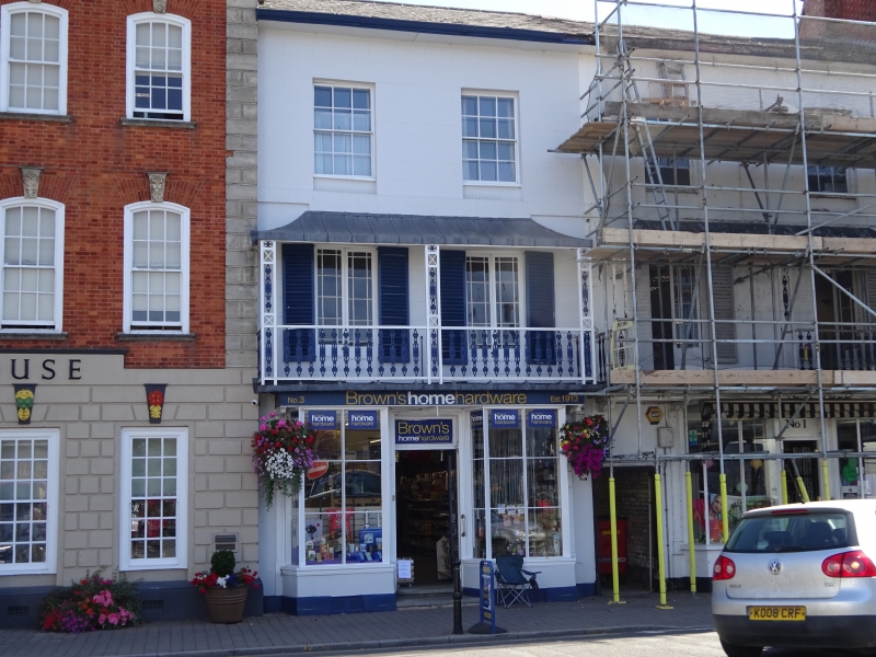
House and shop. Early C19 with later alterations. Brick
rendered with lined stucco. Welsh-slate roof of shallow pitch
with deep eaves soffit and moulded cornice.
EXTERIOR: 3 storeys and cellar; 2-window range. On 2nd floor,
6/6 sashes in deeper reveals. 1st floor: plat band; tall
casement windows of 4+4 panes with margin lights, lower dado
panels, and shutters; windows open on to cast-iron verandah
which has hipped painted lead roof, wooden floor, console and
paterae frieze on underside, wooden end brackets, and is
partly masked by blind and fittings. Ground floor: 2 canted
shop bay-windows of 3:6:3 panes of plate glass with blocked
cellar grilles in plinths; central doorcase which has panelled
reveal, glazed 2-leaf 6-pane door, and overlight with renewed,
lettered, mirror.
INTERIOR: dogleg staircase, lower flight turned in C20; old
kitchen fireplace and flagstones to rear.
HISTORICAL NOTE: formerly a mercer's and wool stapler's
premise and owned by the Ganderton family until the C20; the
derelict building to rear (not included) was formerly a wool
barn; in use as an ironmonger's since 1870.
Listing NGR: SO9499845746
External links are from the relevant listing authority and, where applicable, Wikidata. Wikidata IDs may be related buildings as well as this specific building. If you want to add or update a link, you will need to do so by editing the Wikidata entry.


Other nearby listed buildings
