Approximate Location Map
Large Map »
Latitude: 52.1101 / 52°6'36"N
Longitude: -2.0745 / 2°4'28"W
OS Eastings: 394996
OS Northings: 245752
OS Grid: SO949457
Mapcode National: GBR 2JM.QBD
Mapcode Global: VHB0R.0758
Plus Code: 9C4V4W6G+26
Entry Name: Midland Bank
Listing Date: 11 February 1965
Last Amended: 30 March 1999
Grade: II
Source: Historic England
Source ID: 1387056
English Heritage Legacy ID: 474472
ID on this website: 101387056
Location: Pershore, Wychavon, Worcestershire, WR10
County: Worcestershire
District: Wychavon
Civil Parish: Pershore
Built-Up Area: Pershore
Traditional County: Worcestershire
Lieutenancy Area (Ceremonial County): Worcestershire
Church of England Parish: Pershore
Church of England Diocese: Worcester
Tagged with: Bank building
PERSHORE
SO9445 HIGH STREET
648-1/5/113 (East side)
11/02/65 No.5
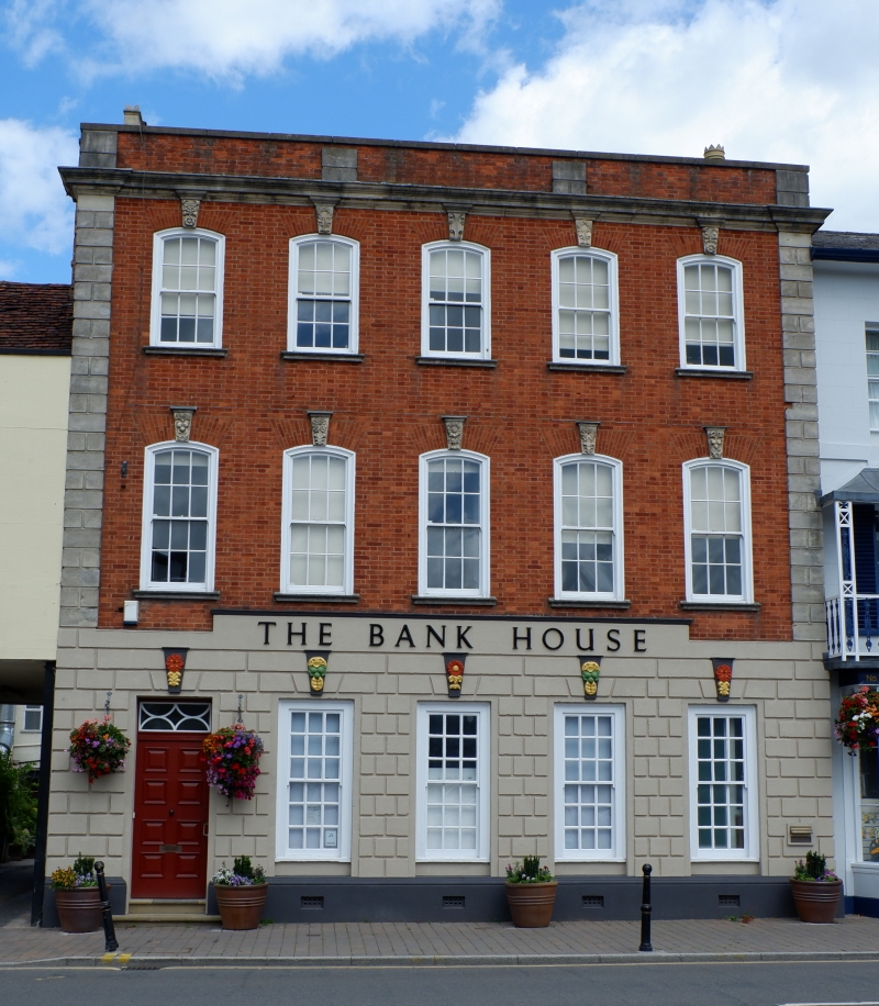
Midland Bank
(Formerly Listed as:
HIGH STREET
(East side)
Midland Bank)
GV II
House now bank. C18 partly remodelled C20. Red brick in
Flemish bond with stone dressings, rusticated stucco ground
floor and quoins. High brick and stone parapet has stone
coping with deep moulded eaves cornice concealing plain tile
roof; 2 lateral brick stacks.
EXTERIOR: 3 storeys and cellar; 5-window range. Windows on 1st
and 2nd floors have: 6/6 sashes; segmental-headed moulded
architraves; deep, gauged brick, segmental arches with heavy
carved keystones; stone sills; 2nd-floor windows smaller. On
ground floor: four boxed 9/9 sashes with large moulded
pseudo-keystones and deeper reveals; doorcase on left with
decorative overlight and C20 door; deep moulded plinth with
cellar grilles. Left return, part rendered and part painted,
has segmental-headed sash windows with sills and wooden
keystones. Rear has double-depth wing.
INTERIOR: not inspected.
HISTORICAL NOTE: formerly partly occupied by bank and partly a
draper's business.
Old photograph shows present parapet is reduced by 2 courses.
(BoE: Pevsner N: Worcestershire: Harmondsworth: 1968-: 243; ).
Listing NGR: SO9499645752
External links are from the relevant listing authority and, where applicable, Wikidata. Wikidata IDs may be related buildings as well as this specific building. If you want to add or update a link, you will need to do so by editing the Wikidata entry.


Other nearby listed buildings
