Approximate Location Map
Large Map »
Latitude: 51.8991 / 51°53'56"N
Longitude: -2.0738 / 2°4'25"W
OS Eastings: 395015
OS Northings: 222283
OS Grid: SO950222
Mapcode National: GBR 2M4.Y8F
Mapcode Global: VHB1Q.0JHJ
Plus Code: 9C3VVWXG+JF
Entry Name: Essex House (Number 18) and Attached Area Railings
Listing Date: 14 December 1983
Grade: II
Source: Historic England
Source ID: 1387777
English Heritage Legacy ID: 475769
ID on this website: 101387777
Location: Cheltenham, Gloucestershire, GL50
County: Gloucestershire
District: Cheltenham
Electoral Ward/Division: College
Parish: Non Civil Parish
Built-Up Area: Cheltenham
Traditional County: Gloucestershire
Lieutenancy Area (Ceremonial County): Gloucestershire
Church of England Parish: Cheltenham, St Mary with St Matthew
Church of England Diocese: Gloucester
Tagged with: Architectural structure
SO9522SW CHELTENHAM RODNEY ROAD
(South East side)
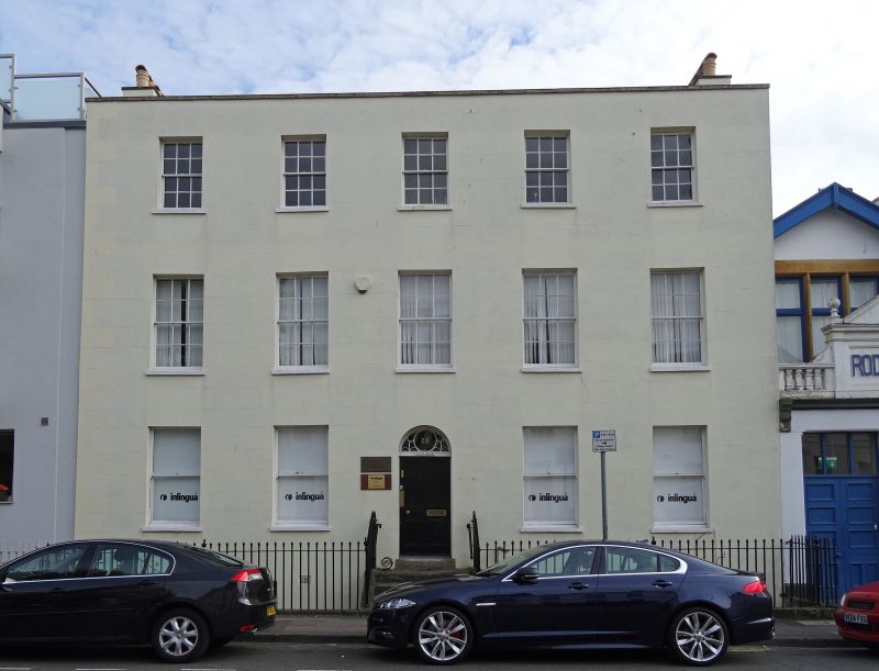
630-1/14/787 Nos. 16A and 18
Essex House (No.18)
and attached area railings
14/12/83
GV II
House, now house and office and attached area railings. Circa 1803. Developer, J Smith, plumber. Stucco over brick with concealed roof and stucco stacks; iron railings. Single depth plan with central hallway.
EXTERIOR: 3 storey on basement, 5 first-floor windows with single storey extendion to the left. 6/6 sashes where original, all in plain reveals and with sills. Basement has 6/6 sashes in cambered-arched surrounds. 5 steps to central entrance to main block, flight of steos to 4-panel door in fluted frieze and fanlight, with batwing and circle glazing bars. Further entrance to extension, 6-flush-panel door with overlight. Low parapet with copings.
INTERIOR: No.18 retains original plasterwork and joinery; embellished cornices with acanthus motif; panelled shutters; narrow-open-well staircase with stick balusters and wreathed handrail with embellished tread ends; doors have tooled architraves with fleurons.
SUBSIDIARY FEATURES: area lancet railings with urn finials to stanchions. Boot scraper to top step. HISTORICAL NOTE: land for the development was bought from Joseph Pitt in 1803; the first occupant was Mr Cooke, a surgeon (information from deeds). Building had commenced on Rodney Road by 1809 and many houses are shown on the Post Office Map of 1820.
Listing NGR: SO9502422291
External links are from the relevant listing authority and, where applicable, Wikidata. Wikidata IDs may be related buildings as well as this specific building. If you want to add or update a link, you will need to do so by editing the Wikidata entry.


Other nearby listed buildings
