Latitude: 51.8933 / 51°53'35"N
Longitude: -2.0831 / 2°4'59"W
OS Eastings: 394378
OS Northings: 221644
OS Grid: SO943216
Mapcode National: GBR 2MB.85V
Mapcode Global: VH947.VN3Y
Plus Code: 9C3VVWV8+8Q
Entry Name: Raynsford
Listing Date: 14 December 1983
Grade: II
Source: Historic England
Source ID: 1387982
English Heritage Legacy ID: 475978
ID on this website: 101387982
Location: Montpellier, Cheltenham, Gloucestershire, GL50
County: Gloucestershire
District: Cheltenham
Electoral Ward/Division: Park
Parish: Non Civil Parish
Built-Up Area: Cheltenham
Traditional County: Gloucestershire
Lieutenancy Area (Ceremonial County): Gloucestershire
Church of England Parish: Leckhampton St Philip and St James
Church of England Diocese: Gloucester
Tagged with: Building
CHELTENHAM
SO9421NW SUFFOLK SQUARE 630-1/17/874 (West side) 14/12/83 No.24 Raynsford
GV II
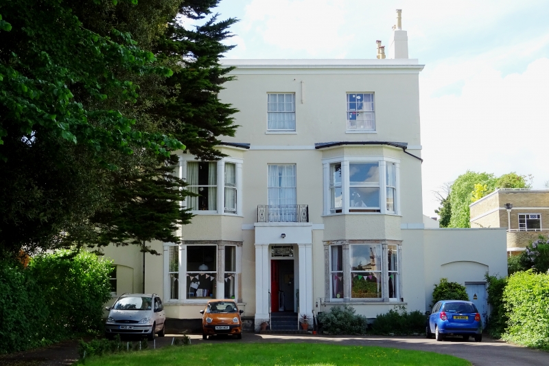
House. c1823-34 with later additions and alterations including later C19 bay windows. Probably by Edward Jenkins for developer, James Fisher. Stucco over brick with concealed roof, 4 end stucco and brick stacks; iron balcony. EXTERIOR: 3 storeys, 3 first-floor windows, with 2-storey single bay to left and single-storey bay to right. Main range: stucco detailing includes floor bands and crowning cornice with blocking course. Canted outer bays through 2 storeys have 1/1 sashes and crowning cornices. First floor has central 6/9 sash with margin lights and second floor has 6/6 sashes with margin-lights in plain reveals and with sills. Central entrance, flight of steps to 6-panel, part-glazed door with overlight with glazing bars in doorcase with paired Doric pilasters and entablature. End ranges: ground floors have elliptically-arched recess with 1/1 sash to left and door to right; first floor to left has 1/1 sash. INTERIOR: not inspected. SUBSIDIARY FEATURES: first floor balcony to centre window has oval and circle motif. HISTORICAL NOTE: Suffolk Square occupies land bought by the Earl of Suffolk from the de la Bere family, on which he built Suffolk House from his own residence; his daughter later sold much of the land, on which Suffolk Square now stands. Land for the Square was bought by developer James Fisher in 1823, villas on the west side are shown on Merrett's 1834 Map. All the listed buildings in Suffolk Square form a very distinguished group. (Merrett HS: Plan of the Town of Cheltenham: 1834-; Blake S: Notes).
Listing NGR: SO9437721649
External links are from the relevant listing authority and, where applicable, Wikidata. Wikidata IDs may be related buildings as well as this specific building. If you want to add or update a link, you will need to do so by editing the Wikidata entry.


Other nearby listed buildings