Approximate Location Map
Large Map »
Latitude: 57.0471 / 57°2'49"N
Longitude: -3.0364 / 3°2'11"W
OS Eastings: 337215
OS Northings: 795588
OS Grid: NO372955
Mapcode National: GBR WF.B5TK
Mapcode Global: WH7NL.B49G
Plus Code: 9C9R2XW7+RC
Entry Name: Royal Bridge, Ballater
Listing Name: Ballater, Royal Bridge
Listing Date: 16 April 1971
Category: B
Source: Historic Scotland
Source ID: 357286
Historic Scotland Designation Reference: LB21851
Building Class: Cultural
Also known as: Ballater Bridge
ID on this website: 200357286
Location: Ballater
County: Aberdeenshire
Town: Ballater
Electoral Ward: Aboyne, Upper Deeside and Donside
Traditional County: Aberdeenshire
Tagged with: Arch bridge Road bridge Stone bridge
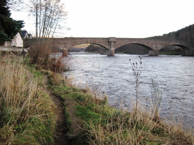
Jenkins & Marr, engineers, 1885. 4-span segmental arched bridge over River Dee forming gateway to Ballater at E. Squared and coursed pink granite with pinning stones. Simple stepped parapet with saddleback coping. Bullnosed cutwaters, those to centre carried up and corbelled out to form pair of recessed refugees with inscriptions. (see Notes) Pair of engaged circular piers to approach to both W and E with rounded caps.
The building of a bridge from Ballater across the River Dee was the vital link which allowed the town to develop. The Pannanich Wells on the East side of the River Dee became famous in the mid 18th century as a place where cures could be found. As the Wells became more famous, increasing numbers of visitors came to the site. The hotel at the Wells themselves proved inadequate accommodation and more was required. Francis Farquharson of Monaltrie, and later his brother William, planned the town of Ballater to provide this extra accommodation, but a bridge was necessary. The first was built in 1783, 100m east of the present bridge. This initial bridge was destroyed by flooding in 1799. The second, built by Thomas Telford in 1809 was again destroyed by floodwater - the 'Muckle Spate' of 1829. A wooden bridge built in 1834 lasted until 1885 when it was superseded by the present one. This fourth bridge was opened by Queen Victoria in 1885.
External links are from the relevant listing authority and, where applicable, Wikidata. Wikidata IDs may be related buildings as well as this specific building. If you want to add or update a link, you will need to do so by editing the Wikidata entry.


Other nearby listed buildings
