Latitude: 56.3371 / 56°20'13"N
Longitude: -2.7838 / 2°47'1"W
OS Eastings: 351639
OS Northings: 716356
OS Grid: NO516163
Mapcode National: GBR 2R.4QK5
Mapcode Global: WH7S0.6ZM9
Plus Code: 9C8V86P8+RF
Entry Name: 4 Balfour Place
Listing Name: 4 and 5 Balfour Place
Listing Date: 30 September 2005
Category: C
Source: Historic Scotland
Source ID: 398066
Historic Scotland Designation Reference: LB50156
Building Class: Cultural
ID on this website: 200398066
Location: St Andrews
County: Fife
Town: St Andrews
Electoral Ward: St Andrews
Traditional County: Fife
Tagged with: Architectural structure
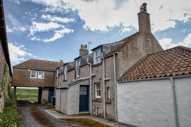
Circa 1820, single storey and attic, 6-bay East Neuk style former timber yard worker's accommodation with later alterations and additions, principally by Gillespie & Scott circa 1946. Harled with pantiles with slate easing course to S elevation. Slated catslide dormers breaking eaves.
SOUTH (PRINCIPAL ENTRANCE) ELEVATION: predominantly regular elevation with single light openings excepting bipartite window to 3rd bay ground floor.
NORTH ELEVATION: lean-to with door provides entrance to No 4. To left, half hipped pantiled circa 1974 attic floor extension set at right angles over square-headed pend.
EAST ELEVATION: overlooks Kinness Burn, canted oriel to ground. Single attic window.
Predominantly 12-pane and 6-pane over 2-pane timber sash and case windows with horns. Pantiles and slate as noted above. Gable end stacks and central ridge stack.
INTERIOR: predominantly circa 1946 work. Good quality timberwork, panelled doors.
Constructed as accommodation for workers at the adjacent timberyard and sawmill (see listing for 6,7,8 Balfour Place) owned by Mr Balfour of Balfour House (see separate listing). Originally divided into many flats the building is now 2 properties. A historic photograph in possession of one of the owners shows the building in use as workers accommodation with a pair of brick and timber forestairs on the South elevation providing access to the upper floor flats. Around 1938/9 the building was declared unfil for human habitation and lay empty until being converted by the local firm, Gillespie & Scott into 2 houses. By circa 1895 the site appears to have been in the possession of the Bruce family and they are noted as the owner on the Gillespie & Scott plans. An important part of St Andrews industrial heritage in an area where reminders of this type are becoming increasingly rare. Of interest as an early illustration of a conversion of a historic building to form housing in St Andrews and as an example of the work of Gillespie & Scott.
External links are from the relevant listing authority and, where applicable, Wikidata. Wikidata IDs may be related buildings as well as this specific building. If you want to add or update a link, you will need to do so by editing the Wikidata entry.


Other nearby listed buildings