Approximate Location Map
Large Map »
Latitude: 55.8559 / 55°51'21"N
Longitude: -4.2702 / 4°16'12"W
OS Eastings: 257993
OS Northings: 664851
OS Grid: NS579648
Mapcode National: GBR 0HN.GK
Mapcode Global: WH3P8.C2TM
Plus Code: 9C7QVP4H+9W
Entry Name: Kingston Bridge, Glasgow
Listing Name: Kingston Bridge (bridge only), Glasgow
Listing Date: 11 November 2020
Category: C
Source: Historic Scotland
Source ID: 407402
Historic Scotland Designation Reference: LB52554
Building Class: Cultural
ID on this website: 200407402
Location: Glasgow
County: Glasgow
Electoral Ward: Anderston/City/Yorkhill
Parish: Glasgow
Traditional County: Lanarkshire
Tagged with: Road bridge Cantilever bridge Box girder bridge
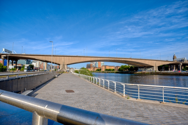
The bridge has an independent cantilevered design comprising two pre-stressed concrete box girder spans, with a separation gap between them, each with a deck carrying five lanes of traffic. The bridge is 42 metres wide. The main span over the river is 143 metres with balancing spans of 62.5m to either side. The clearance height is 18m above the water. The sides of the bridge are clad with polished stone aggregate panels with vertical joints. There are engaged tapering pillars designed to look like cutwaters at the foot of each pier. The northwest pier has a bronze dedication date plaque. Two rows of four parabolic-shaped concrete supporting columns, one at either end where the bridge joins the elevated approach road, are also included in the listing.
Historical development
A bridge crossing the Clyde between Anderston and Kingston was first proposed in 1945 as part of the Glasgow Inner Ring Road scheme, which sought to address the growing problem of traffic congestion in the centre of the city. In 1963 the Scottish Office published a paper called Central Scotland - A Programme for Development & Growth which put improvements to roads at the heart of economic planning. Construction on the Glasgow Inner Ring Road began in 1965. It was planned as a circular urban motorway around the city centre to route traffic away from the central area (Fairhurst, 1971). Only the north and west flanks were constructed, which now carry the M8 motorway through the city.
Alternative designs were drawn up for a bridge to carry the route over the River Clyde, with both a high and a low-level crossing (with motorway traffic above and pedestrian and local traffic below). This idea was abandoned to allow larger dredging boats to pass beneath and reach further upriver.
The single-deck, free cantilevered bridge design by W. A. Fairhurst was agreed upon because it enabled building to proceed without significant interruptions to traffic in the busy neighbouring streets and to the navigation of the Clyde (Fairhurst, 1971). Construction work on the bridge (and its approaches) began in May 1967. It was officially opened by the Queen Mother on 26 June 1970. The cost of the bridge itself was around £2.4 million. An important aspect of the design was maintaining and diverting £400,000 of public utility services during construction.
The name of the bridge was derived from the nearby docklands area of the city, which in turn may have taken its name from Kingston, Jamaica, as ships regularly departed here for the West Indies during the height of mercantile trade between Glasgow and the Caribbean. Throughout Scotland there are many places called Kingston (such as in Angus, East Lothian and Renfrewshire), and places with this name can also be found in Ireland, Wales and southern England. There is extensive crossover of place-names between Jamaica and Scotland, which reflects the period of heavy Scots involvement in the transatlantic slave economy of the 18th and early 19th centuries.
The bridge, which was at first owned and maintained by the Glasgow Corporation, became part of the trunk road network in 1986, meaning that it came under the control of central Government. By the late 1980s, small movements in the adjoining quay wall and concrete spalling at the base of the bridge piers had become a concern (Civil Engineering Heritage, 2007). This led to a major strengthening and lifting works between 1996 and 2001. The entire 50,000 tonne bridge superstructure was moved 5cm to the south using 128 custom-built hydraulic jacks. Evidence of the strengthening is visible as a grid of pinned plates on the underside of the outer spans of the bridge. The function and general appearance of the bridge has not changed significantly since its completion in 1970 (2020).
Kingston Bridge meets the criteria of special architectural or historic interest for the following reasons:
Architectural interest
Design
The Kingston Bridge is a modernist bridge design characterised by its clean lines and simple proportions, which are primarily achieved by the arrangement of the (parabolic) colonnaded piers and the shallow profile of the decks and cantilevered arches.
Initially developed for military use in the earlier half of the 20th century, box girder bridges were widely used across the western world in the expansion of road networks during the 1960s. Many examples are plain and functional in their treatment but the overall form and appearance of the Kingston Bridge was design-led, and this is particularly evident when viewed from below. When compared with other examples of the box girder type, the Kingston Bridge has special design interest for its date.
The three-dimensional nature of the bridge's design means that all the elevations, including the undercarriages, were fully considered. Most notably, the gap which separates the two parallel bridge decks and the arched cantilevers is visible from the underside of the bridge. This gives dramatic views upwards from beneath the bridge and lightens the visual weight of this large-scale structure.
Materials and finishes are an important aspect of the modern design. High-quality, polished stone aggregate panels were used with a specific type of aggregate chosen to prevent staining in the harsh inner-city conditions. More than utilitarian, these panels were more often applied to high-spec office buildings than civil engineering structures. The aim was to integrate the bridge with the built-up, inner-urban river setting as far as possible (Fairhurst, 1971), which at the time was being transformed with new office blocks and housing schemes.
The overall form of the bridge was driven by the need for large dredging boats to be able to pass underneath, so that the shipping channel could remain open. This serves a reminder of the relatively recent time when the Clyde was navigated right into the centre of Glasgow.
The pre-stressed concrete box girders were cast 'in-situ' as free cantilevers to allow the neighbouring streets, and the River Clyde, to remain largely open during construction. The design experimented with the use of internal ballasting within the concrete superstructure, to avoid the need for longer and more expensive side spans and to achieve well-balanced proportions between the main and side spans. Cutting-edge computer technology was used by Fairhurst to calculate and predict the various forces that would impact on the bridge structure, including deflection and deformation.
The parabolic supporting columns that elevate the approach roads and access ramps (not part of the listing) are mostly between 10 and 30 metres in height. They were adapted from William Fairhurst's earlier design for the Tay Road Bridge, 1959-66. The Kingston Bridge is independently cantilevered and therefore is not directly supported by the adjoining approach roads.
The designer-engineers are also significant in relation to the structure's special interest. Fairhurst (now one of the largest engineering consultancy companies in the UK) are an important company in the history of bridge design in Scotland. Formed in 1902 as F.A. Macdonald & Partners, William Fairhurst joined the company in 1931 having established his reputation as a civil and structural engineer. The new Tay Road Bridge, linking Fife with Dundee, was pivotal in the firm's development, leading to the business changing its name to W. A. Fairhurst and Partners. Fairhurst retired in 1971, by which time the business had also completed the Kingston Bridge.
The strengthening and lifting works to the bridge were carried out by Balfour Beatty between 1996 and 2001. The work was a significant engineering achievement in its own right and won the Saltire Award for civil engineering excellence in Scotland and the Institution of Civil Engineers' Brunel Medal. Strengthening works are common in road bridges of this period, largely due to the introduction of new safety codes and improved design standards from the 1970s onwards but also due to increased traffic loads. A large number of road bridges across Scotland have been strengthened, including the Erskine Bridge, albeit these are to a lesser degree than at Kingston Bridge.
This later alteration, as well as other minor changes and adaptations over the years, have not adversely affected the bridge's design, modernist character or level of authenticity.
Setting
The Kingston Bridge is situated in a strategic and prominent location near the centre of the city of Glasgow, crossing over the River Clyde between Kingston on the south side and Anderston on the north. The design was conceived to be a practical means of connecting the north and south of the city but also to be seen from several points of view, both near and far and from all directions. Combined with its height, this gives the bridge a landmark quality within the urban centre.
The bridge is linked to a complex network of contemporary infrastructural elements including approach roads and the pedestrian flyover to the north side of the bridge. The complexity of this infrastructure demonstrates how the Kingston Bridge is one of the most significant links in the chain of Scotland's motorway network. These integrated elements are a standard type of elevated road structure for their date and are not of special architectural or historic interest. However, they are of interest as part of the road infrastructure associated with Kingston Bridge, forming part of its immediate setting. They add to the concept of the urban picturesque along Clydeside and are now a familiar landmark in Glasgow city centre.
The M8 motorway is the main artery through the city, passing many important and historic buildings. Those sited near the Kingston Bridge and its approaches include Co-Operative House (LB33971), 1897, to the southeast; the former warehouse (LB33211), 1897-1907, and former public school (LB45642), 1890, on Washington Street, to the northeast; and the Mitchell Library (LB33095), 1906-11, and St Patricks' RC Church (LB33093), 1898, to the northwest.
The construction of the bridge and the associated elements was a unified piece of major infrastructure that required large parts of existing streets to be knocked down and totally reconfigured. However, the route was planned so that the demolition of existing fabric would be as minimal as possible. The banks of the Clyde in the general vicinity of the Kingston Bridge have seen much commercial and residential redevelopment in recent years, typical of inner-city urban environments. The newer developments continue to provide an appropriate inner-urban setting for the bridge.
Historic interest
Age and rarity
While later 20th century road bridges are not an uncommon building type in Scotland, Kingston Bridge (1966-70) is an important example and among the most significant in the country.
Kingston Bridge is one of several high-profile bridge projects completed in Scotland during the 1960s and 1970s. Among them the Forth Road Bridge (1958-64, listed category A, LB47778) which, when opened, was the longest suspension bridge outside of the USA; Tay Road Bridge (1959-66, not listed) which is still among the longest road bridges in Europe; Erskine Bridge (1967-71, listed category A, LB52482) which is the only remaining mono cable-stayed road bridge in Britain; and Kessock Bridge (1972-76, listed category B, LB52506) which was the largest multi cable-stayed bridge (length, weight and height) in Europe at the time of its completion in 1982.
Kingston Bridge is an important component of the major post-war infrastructural investment in the new road and motorway networks. It was an early example of the cantilevered concrete box girder road bridge in the United Kingdom. The first of this type was Medway Bridge, Kent (1962-65) by Freeman, Fox and Partners. The Kingston Bridge is relatively early and experimentally large example of this type of design.
Social historical interest
Kingston Bridge is of special social historical interest within the context of post-war road building in Scotland.
The bridge is part of the M8, Scotland's first motorway. It is a key part of what was known as the Glasgow Inner Ring Road, first proposed in 1945 to address Glasgow congestion. The Kingston Bridge is a strategically important bridge providing the primary crossing of the River Clyde for both regional and local traffic networks. The listing of the bridge serves to represent the wider engineering achievement of the M8 motorway scheme.
Post-war optimism and an appetite for grand civic projects saw the rapid construction and infrastructural investment in new road and motorway networks across the United Kingdom. Increased reliance on the motor car meant that an integrated road network became a priority in Scotland's largest city, where the use of private cars and the need for commercial road transport was most pressing. As such, the bridge is one of the key signifiers of the impact that private car ownership had on major urban centres in the mid-late 20th century, and how plans were made to address this cultural transformation.
The most important scheme in the west of Scotland during this period was the opening of the M8 in 1965, completed through Glasgow and further connecting the Greater Glasgow area to the west through to the airport at Abbotsinch. The infrastructure scheme for the M8 and the Clyde, which included the building of the Kingston Bridge, the Erskine Bridge and the Clyde Tunnel, were, along with the Tay Bridge (1966) and the Forth Road Bridge (1964) in the east of Scotland, the most significant projects of the time.
Other key elements of the wider Glasgow transport link include the Harthill Bypass, the Ballieston Interchange, the Clydeside Expressway, the Charing Cross Section and the Scotland Street Viaduct. The inner-urban section of the motorway through the city centre is road building on a scale and ambition not seen elsewhere in Scotland, and rarely in Europe more widely.
In 1966 it was anticipated that over 120,000 vehicles would be using the bridge daily by 1990 (Structural Engineer, 1971). The daily average is currently between 150,000 and 160,000 commercial and private vehicles. The bridge is by some distance the most used road bridge in Scotland and amongst the busiest in Europe. It is of great social and economic importance to Scotland as a strategic transport link, giving it special interest under this heading.
Since its construction, the bridge and the inner-urban section of the M8, has had, and continues to have, significant impact on the city as a whole but particularly on the areas immediately surrounding it. These include detrimental environmental implications, such as increased traffic, pollution and noise, as well as the physical barriers it has created to pedestrians and cyclists. There are also social and cultural consequences. Existing buildings were destroyed, neighbourhoods were displaced and the surrounding communities of Anderston, Kingston, Charing Cross, Tradeston and the Gorbals, were socially and physically cut-off.
These implications remain to this day but at the time the construction of the bridge was a key move in revitalising the city and modernising the transport infrastructure during the aspirational optimism of the post-war period. Despite the undeniable shortcomings of the transport policy under which it was built, the bridge is of special social historical interest as one of the most important pieces of infrastructure of the post-war period which completely changed the face of the city.
Association with people or events of national importance
The Kingston Bridge has no direct association with a person or event of national importance.
External links are from the relevant listing authority and, where applicable, Wikidata. Wikidata IDs may be related buildings as well as this specific building. If you want to add or update a link, you will need to do so by editing the Wikidata entry.


Other nearby listed buildings