History in Structure

Groed Onen Windmill

A Grade II Listed Building in Holywell, Flintshire

More Photos »
Approximate Location Map
Large Map »

Coordinates

Latitude: 53.2732 / 53°16'23"N

Longitude: -3.2153 / 3°12'55"W

OS Eastings: 319051

OS Northings: 375826

OS Grid: SJ190758

Mapcode National: GBR 5ZZL.PC

Mapcode Global: WH76K.LZ3K

Plus Code: 9C5R7QFM+7V

Entry Name: Groed Onen Windmill

Listing Date: 26 July 1951

Last Amended: 19 August 1991

Grade: II

Source: Cadw

Source ID: 515

Building Class: Industrial

ID on this website: 300000515

Location: Set back from the bend in the road on the edge of the town centre.

County: Flintshire

Community: Holywell (Treffynnon)

Community: Holywell

Locality: Pen-y-Maes

Built-Up Area: Holywell

Traditional County: Flintshire

Tagged with: Windmill

Find accommodation in
Holywell

Exterior

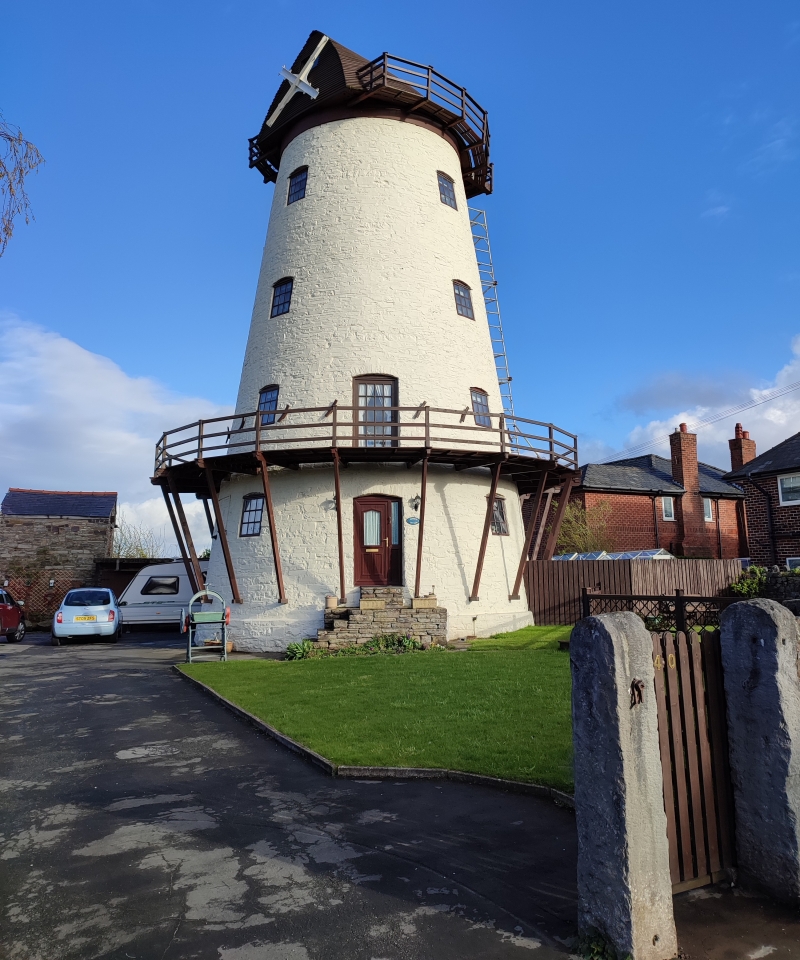
Basingwerk Abbey is believed to have erected a windmill on this site. The present structure is however probably late C18 or ca 1800. The windmill has been restored over the last 10 years.

Conical tower windmill, stone built with plinth; recently whitewashed (Autumn 1990). Replaced weatherboarded boat-shaped cap with timber balcony except on sail side. 4-storeys with camber-arched headed openings and modern small-pane, top-hung windows arranged in regular tiers. 2-modern doors to N, the upper one opens onto a 1st floor balcony carried on raking timber struts springing from plinth; iron cleats.

Reasons for Listing

Listed as a prominent local landmark and as a rare surviving Welsh example of a full height windmill.

External Links

External links are from the relevant listing authority and, where applicable, Wikidata. Wikidata IDs may be related buildings as well as this specific building. If you want to add or update a link, you will need to do so by editing the Wikidata entry.

Recommended Books

Other nearby listed buildings

  • II Masonic Hall
    Long building at right angles to the road and to left of Nos 10 and 12; set back behind walled forecourt.
  • II Territorial Army Drill Hall
    Midway along the street, at a splayed angle. Rubble boundary wall with brick gate piers.
  • II Old Bank House
    Set back behind raised forecourt with railings curving around at ends, at right running back towards screen wall linking No 10 and the neighbouring chapel; round arched entrance to courtyard of Maes-y
  • II Maes-Y-Dre
    Set back behind raised forecourt with railings curving around at ends, at right running back towards screen wall linking No 10 and the neighbouring chapel; round arched entrance to courtyard of Maes-y
  • II Tabernacle English Congregational Church
    Set back from the road behind walled and railed forecourt with pedimented end piers.
  • II 9
    Midway along the street, at a splayed angle. Rubble boundary wall with brick gate piers.
  • II Hotel Victoria
    Detached, facing NW down the High Street; Halkyn Street to right.
  • II Holywell County Court
    Detached forward to the street.

BritishListedBuildings.co.uk is an independent online resource and is not associated with any government department. All government data published here is used under licence. Please do not contact BritishListedBuildings.co.uk for any queries related to any individual listed building, planning permission related to listed buildings or the listing process itself.

British Listed Buildings is a Good Stuff website.