History in Structure

Carriage shelter at Whitewell Church

A Grade II Listed Building in Bronington, Wrexham

More Photos »
Approximate Location Map
Large Map »

Coordinates

Latitude: 52.9673 / 52°58'2"N

Longitude: -2.754 / 2°45'14"W

OS Eastings: 349455

OS Northings: 341375

OS Grid: SJ494413

Mapcode National: GBR 7H.K3JZ

Mapcode Global: WH89G.NPR1

Plus Code: 9C4VX68W+W9

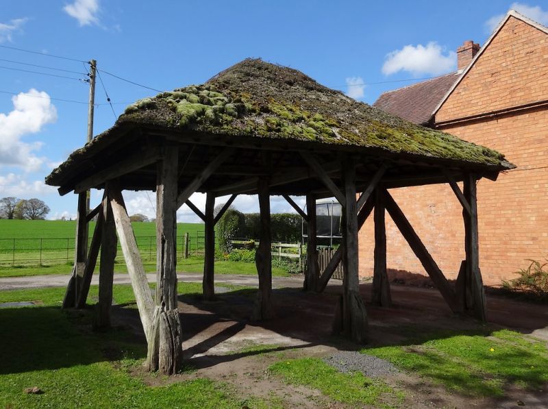
Entry Name: Carriage shelter at Whitewell Church

Listing Date: 16 November 1962

Last Amended: 20 October 2005

Grade: II

Source: Cadw

Source ID: 1674

Building Class: Domestic

ID on this website: 300001674

Location: On the E side of the churchyard, adjacent to Church House.

County: Wrexham

Community: Bronington

Community: Bronington

Locality: Whitewell

Traditional County: Flintshire

Tagged with: Architectural structure

Find accommodation in
Whitchurch

History

A shelter of the C17 or C18, and shown on an Iscoyd Park estate plan of the 1830s.

Exterior

A 2-bay open-sided shelter on timber posts with diagonal tension braces to the sides, brackets to the front and rear, and hipped thatch roof.

Reasons for Listing

Listed for its special historic interest as an unusual and well-preserved C17 shelter in traditional materials, and with the adjacent stables and Church House for its contribution to the setting of the parish church.

External Links

External links are from the relevant listing authority and, where applicable, Wikidata. Wikidata IDs may be related buildings as well as this specific building. If you want to add or update a link, you will need to do so by editing the Wikidata entry.

Recommended Books

Other nearby listed buildings

  • II Stable at Whitewell Church
    On the W side of the churchyard and the W end of a group comprising stable, carriage shelter and Church House.
  • II Church of St Mary
    At the end of a lane reached by minor roads N of the A525 and approximately 1.3km WNW of Redbrook road junction.
  • II Church Holding
    On the N side of the lane leading to the church, approximately 150m WSW of the church.
  • II Shippon at Church Holding
    On the SW side of the house.
  • II Miles Cottage
    On the S side of a minor road between Whitewell and Iscoyd Park, approximately 300m N of Whitewell church.
  • II Parkley Lodge
    At the entrance to Parkley Farm on the S side of a minor road between Whitewell and Iscoyd Park, approximately 350 NW of Whitewell church.
  • II The Old Rectory
    Set back from the road in its own grounds W of the parish hall and approximately 350m SSE of Whitewell church.
  • II Whitewell parish hall
    Fronting the road approximately 350m SSE of Whitewell church.

BritishListedBuildings.co.uk is an independent online resource and is not associated with any government department. All government data published here is used under licence. Please do not contact BritishListedBuildings.co.uk for any queries related to any individual listed building, planning permission related to listed buildings or the listing process itself.

British Listed Buildings is a Good Stuff website.