History in Structure

Capel y Bedd

A Grade II Listed Building in Holyhead, Isle of Anglesey

More Photos »
Approximate Location Map
Large Map »

Coordinates

Latitude: 53.3112 / 53°18'40"N

Longitude: -4.6327 / 4°37'57"W

OS Eastings: 224700

OS Northings: 382592

OS Grid: SH247825

Mapcode National: GBR GMYY.DPH

Mapcode Global: WH31B.T14D

Plus Code: 9C5Q8968+FW

Entry Name: Capel y Bedd

Listing Date: 26 September 1951

Last Amended: 25 July 1994

Grade: II

Source: Cadw

Source ID: 5414

Building Class: Religious, Ritual and Funerary

ID on this website: 300005414

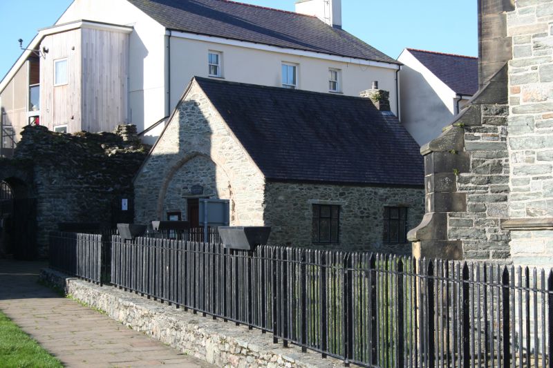
Location: In churchyard overlooking inner harbour, entered by archway from Market Square. To S of St Gybi’s Church near archway to churchyard.

County: Isle of Anglesey

Community: Holyhead (Caergybi)

Community: Holyhead

Built-Up Area: Holyhead

Traditional County: Anglesey

Tagged with: Church building

Find accommodation in
Holyhead

History

Nave of C14 church converted to school in 1748. Also known as Capel. Llan-y-Gwyddel, and Old Vestry

Exterior

Grey stone, slate roof. Former chancel arch to E (now blocked) 2 continuous moulded orders, inserted doorway; to N, 2 square windows. To W, window (C14?) originally 2 lights, with moulded jambs and label; head of blocked C15/C16 doorway below.

Reasons for Listing

Group value with Parish Church and Upper Churchyard walls.

External Links

External links are from the relevant listing authority and, where applicable, Wikidata. Wikidata IDs may be related buildings as well as this specific building. If you want to add or update a link, you will need to do so by editing the Wikidata entry.

Recommended Books

Other nearby listed buildings

  • II Stanley House
    At SE corner of Churchyard, adjacent to entrance arches, with rear facing over Holyhead inner harbour.
  • I Walls of upper churchyard
    Between Stanley Street and Victoria Road enclosing St Gybi’s Church, and Capel-y-Bedd, entered by gateway from Market Square.
  • II The Captains Table
    At SE corner of Churchyard, adjacent to entrance arches, with rear facing over Holyhead inner harbour.
  • I St Cybi's Church
    In chuchyard overlooking inner harbour, entered by archway from Market Square.
  • II Lower Churchyard Walls and Gateway
    Below St Cybi’s Church, parallel to road enclosing lower level of churchyard.
  • II Market Hall
    In town centre on sloping site. Set back and above the street behind single storey shops; side and rear elevations to Summer Hill and Trearddur Square.
  • II Caernarfon Castle P H
    At top of Summer Hill facing down towards Stanley Street.
  • II Tabernacl Chapel
    On corner with Baptist Street.

BritishListedBuildings.co.uk is an independent online resource and is not associated with any government department. All government data published here is used under licence. Please do not contact BritishListedBuildings.co.uk for any queries related to any individual listed building, planning permission related to listed buildings or the listing process itself.

British Listed Buildings is a Good Stuff website.