Approximate Location Map
Large Map »
Latitude: 53.3064 / 53°18'22"N
Longitude: -4.0567 / 4°3'23"W
OS Eastings: 263057
OS Northings: 380797
OS Grid: SH630807
Mapcode National: GBR 0Z36.JG
Mapcode Global: WH53W.N5G3
Plus Code: 9C5Q8W4V+G8
Entry Name: The Holy Well and Cell
Listing Date: 5 February 1952
Last Amended: 17 July 2002
Grade: I
Source: Cadw
Source ID: 5437
Building Class: Religious, Ritual and Funerary
Also known as: Saint Seiriol's Well
St. Seiriol's Well
ID on this website: 300005437
Location: Set back, along a trackway, from the N side of a country road leading to the SE tip of the island at Black Point, or Trwyn Du, Penmon. The Holy Well and Cell are c50m NNE of the Priory Church of St S
County: Isle of Anglesey
Community: Llangoed
Community: Llangoed
Locality: Penmon
Traditional County: Anglesey
Tagged with: Holy well
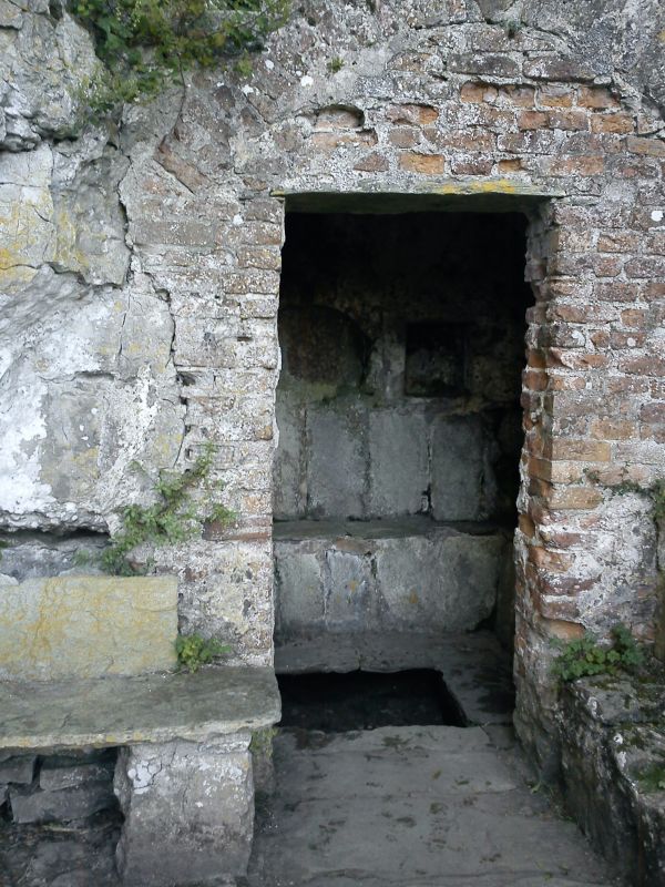
C6 stone foundations of a monk's cell which probably mark the settlement of St Seiriol, founder of the religious community at Penmon. Close by the cell is an ancient well, now with a rectangular stone basin and forecourt. The well is now housed in a red brick and stone shelter; the upper part of which was probably built in the early C18.
Sub rectangular limestone foundations of monks cell standing up to a height of c0.5m. To the NE of the cell is an ancient well, now with a rectangular flagged forecourt with rough limestone walling and crude stone benches along the E and W sides. Over the well is a small red brick and limestone building, built into the cliff face to the W. The building has a shallow gabled roof and a single doorway offset to the W with narrow vent slit to the E. The lower part of the walling is of stone and slightly battered, the brickwork is weathered and the building was once rendered, some remains.
Interior walls are rendered. The open doorway leads into a rectangular chamber, with a rectangular basin for the well set into the flagged stone floor. There are crude flagstone benches along the N and E walls and rectangular recesses in the walls above; one is said (by RCAHM) to have been partly blocked by a slate slab with a coronet above the initials and date B / R B 1710, though this is no longer present.
Listed as the remains of an early Christian site with remains of a C6 monastic cell and ancient well; rare evidence for the form of early religious functions, and with considerable group value in its association with the Priory buildings of Penmon.
Ancient Monument No 1/1838/AN 062 (ANG) G.
External links are from the relevant listing authority and, where applicable, Wikidata. Wikidata IDs may be related buildings as well as this specific building. If you want to add or update a link, you will need to do so by editing the Wikidata entry.


Other nearby listed buildings
