Approximate Location Map
Large Map »
Latitude: 53.3056 / 53°18'20"N
Longitude: -4.057 / 4°3'25"W
OS Eastings: 263033
OS Northings: 380717
OS Grid: SH630807
Mapcode National: GBR 0Z36.GQ
Mapcode Global: WH53W.N59N
Plus Code: 9C5Q8W4V+76
Entry Name: Priory House
Listing Date: 14 November 1968
Last Amended: 21 July 2003
Grade: II*
Source: Cadw
Source ID: 5454
Building Class: Domestic
ID on this website: 300005454
Location: Slightly set back from the N side of a country road leading to the SE tip of the island at Black Point, or Trwyn Du, Penmon. The Priory House forms the W side of a cloister yard; linking the Church to
County: Isle of Anglesey
Community: Llangoed
Community: Llangoed
Locality: Penmon
Traditional County: Anglesey
Tagged with: House
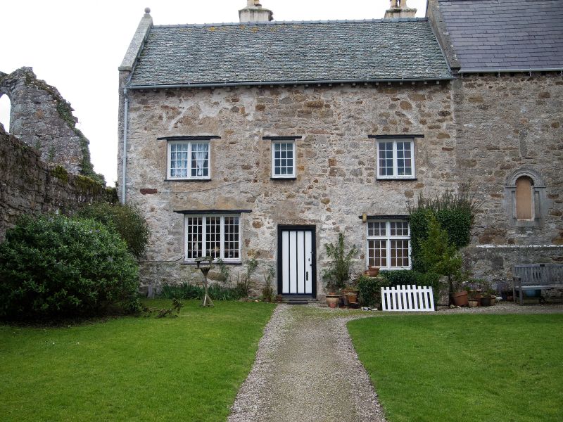
The date of the Priory house is uncertain due to extensive renovations carried out in 1923, when it was also replanned. Some of the walls may be contemporary with the adjacent refectory building, probably built early C13, though its present appearance suggests a C16 or C17 date. Retains some C17 and C18 panelling, some of which was repaired in 1923 and when removed from an upstairs room the initials and date H T W 1711 were found on the plaster behind. Panelling in parlour damaged by woodworm treatment in later C20.
Two storey house with attics and cellars. Built of local rubble masonry, the rear elevation roughcast rendered. Roof of small slates with stone copings on gable parapet to S surmounted by a ball finial. The principal elevation opens into the cloister court to the E; a 3-window range of small-paned casement windows with timber lintels; doorway offset to the R. To the R of the doorway steps lead down to cellar doorway with large stone lintel. The rear elevation is dominated by a pair of large projecting stacks. Casement windows between including a raking dormer and raking half dormer which breaks the eaves line.
Plan form dates from early C20 re-ordering. Central corridor plan with Jacobethan staircase to rear and principal rooms leading off to either side. The central passage contains (to R) some refixed panelling of the early C17 with scratched-mouldings and modern cornice; it originally formed a partition on the 1st floor. The parlour contains oak panelling of the early C18 with moulded cornice and dado (but see "History" above). First floor room has a fireplace, possibly C16, with stone chamfered jambs with broach-stops and a stone lintel carried on ogee-shaped corbels; later brick filling and grate and stonework re-dressed.
Graded II* as a major sub-medieval house which forms an important component of the conventual buildings set around the cloister court by the Priory Church of St Seiriol.
Ancient Monument No 1/1838/AN 027 (ANG) G.
External links are from the relevant listing authority and, where applicable, Wikidata. Wikidata IDs may be related buildings as well as this specific building. If you want to add or update a link, you will need to do so by editing the Wikidata entry.


Other nearby listed buildings
