History in Structure

Dovecote and barn at Penmon Priory

A Grade II* Listed Building in Llangoed, Isle of Anglesey

More Photos »
Approximate Location Map
Large Map »

Coordinates

Latitude: 53.3057 / 53°18'20"N

Longitude: -4.0558 / 4°3'20"W

OS Eastings: 263114

OS Northings: 380718

OS Grid: SH631807

Mapcode National: GBR 0Z36.QQ

Mapcode Global: WH53W.N5WM

Plus Code: 9C5Q8W4V+7M

Entry Name: Dovecote and barn at Penmon Priory

Listing Date: 17 July 2002

Last Amended: 17 July 2002

Grade: II*

Source: Cadw

Source ID: 26763

Building Class: Agriculture and Subsistence

ID on this website: 300026763

Location: Set at the S side of a country road leading to the SE tip of the island at Black Point, or Trwyn Du, Penmon.

County: Isle of Anglesey

Community: Llangoed

Community: Llangoed

Locality: Penmon

Traditional County: Anglesey

Tagged with: Dovecote Barn

Find accommodation in
Llangoed

History

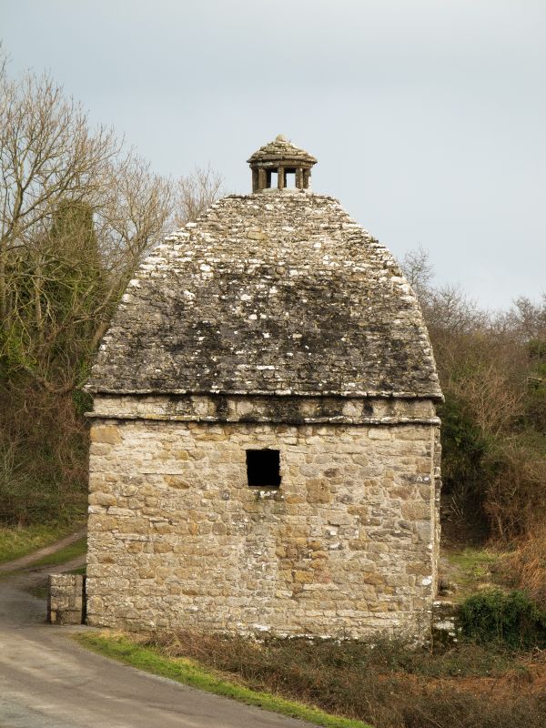
Late C16 or early C17 dovecote, built c1600 and abutted by a later, probably C18, threshing barn.

Exterior

Built of roughly coursed rubble masonry, the dovecote is square in plan with a corbelled stone roof dome surmounted by a a hexagonal latern with small stone dome carried on 6 moulded piers. Below the eaves is a plain square string. The square headed doorway opens out to the road to the N; a small square opening above and corresponding openings in the S and W walls.
The abutting barn is now roofless, with wide opposing segmentally arched doors with voussoir heads and flanking ventilation slits.

Interior

The interior of the dovecote is lined with nesting holes and there is a circular tower with steps in the centre.

Reasons for Listing

Listed as an excellent, well-preserved, late C16 or early C17 dovecote of striking architectural form and adjoining barn standing at the heart of a rich historic landscape which includes the adjacent Priory church with surrounding conventual buildings, the nearby holy well and cell and also the monastic remains at Ynys Seiriol.
Ancient Monument No 1/1838/AN 061 (ANG) G.

External Links

External links are from the relevant listing authority and, where applicable, Wikidata. Wikidata IDs may be related buildings as well as this specific building. If you want to add or update a link, you will need to do so by editing the Wikidata entry.

Recommended Books

Other nearby listed buildings

  • II Priory house outbuilding
    Slightly set back from the N side of a country road leading to the SE tip of the island at Black Point, or Trwyn Du, Penmon. The outbuilding is set in the SE corner of the cloister yard; abutting the
  • I Refectory at Penmon Priory
    Slightly set back from the N side of a country road leading to the SE tip of the island at Black Point, or Trwyn Du, Penmon. The Refectory forms the S side of a cloister yard; abutted by the Priory ho
  • II* Priory House
    Slightly set back from the N side of a country road leading to the SE tip of the island at Black Point, or Trwyn Du, Penmon. The Priory House forms the W side of a cloister yard; linking the Church to
  • I Priory Church of St Seiriol
    Slightly set back from the N side of a country road which leads down to the SE tip of the island at Black Point, or Trwyn Du, Penmon.
  • I The Holy Well and Cell
    Set back, along a trackway, from the N side of a country road leading to the SE tip of the island at Black Point, or Trwyn Du, Penmon. The Holy Well and Cell are c50m NNE of the Priory Church of St S
  • II Enclosure walls at former pilots' cottages for Trwyn Du, or Black Point, Lighthouse
    The walls define a compound around the two former pilots' cottages close to the shore at Black Point, or Trwyn Du, Penmon.
  • II Pilot's Cottage (former) No 1
    Situated at Black Point, or Trwyn Du, Penmon, overlooking the passage between the point and Puffin Island, and close to the access to the lighthouse.
  • II Pilot's Cottage (former No 2)
    Situated at Black Point, or Trwyn Du, Penmon, overlooking the passage between the point and Puffin Island, and close to the access to the lighthouse.

BritishListedBuildings.co.uk is an independent online resource and is not associated with any government department. All government data published here is used under licence. Please do not contact BritishListedBuildings.co.uk for any queries related to any individual listed building, planning permission related to listed buildings or the listing process itself.

British Listed Buildings is a Good Stuff website.