Approximate Location Map
Large Map »
Latitude: 53.3056 / 53°18'20"N
Longitude: -4.0568 / 4°3'24"W
OS Eastings: 263044
OS Northings: 380709
OS Grid: SH630807
Mapcode National: GBR 0Z36.HR
Mapcode Global: WH53W.N5DQ
Plus Code: 9C5Q8W4V+67
Entry Name: Refectory at Penmon Priory
Listing Date: 17 July 2002
Last Amended: 17 July 2002
Grade: I
Source: Cadw
Source ID: 26764
Building Class: Religious, Ritual and Funerary
ID on this website: 300026764
Location: Slightly set back from the N side of a country road leading to the SE tip of the island at Black Point, or Trwyn Du, Penmon. The Refectory forms the S side of a cloister yard; abutted by the Priory ho
County: Isle of Anglesey
Community: Llangoed
Community: Llangoed
Locality: Penmon
Traditional County: Anglesey
Tagged with: Building
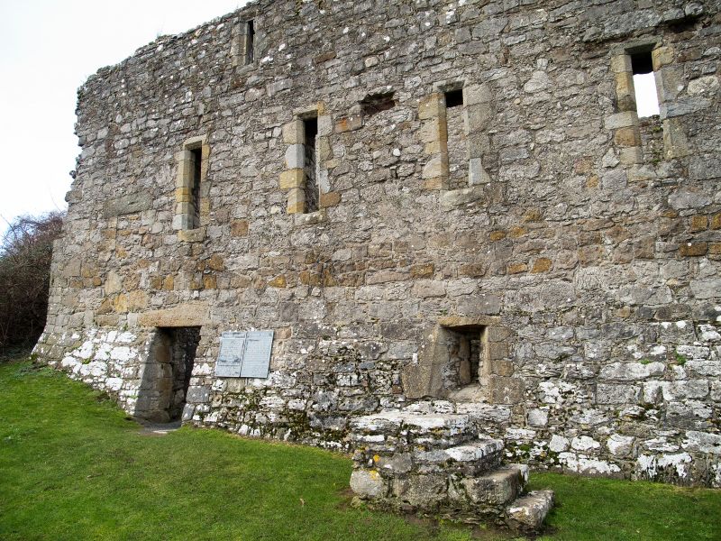
Linear range of monastic buildings, probably contemporary with the chancel of the adjacent church erected in the first half of the C13. Comprising refectory with cellar below and dormitory above and extended by the addition of a warming room and upper rooms at the E end in early C16.
The substantial, roofless, remains of a 3-storey range of monastic buildings built of local rubble masonry with limestone dressings and large boulders as quoins. The refectory is a 5-window range with 3 narrow lights to the dormitory and 3 openings to the cellars below; a doorway to the L and narrow windows with deep slayed reveals to the right. The L (W) return has a tall lancet window in the gable apex and 2 rectangular lights to the refectory. A blocked arched window can be seen from the cloister courtyard to the N.
The warming room addition is built to the E end and has similarly detailed cellar openings with doorway to the R. There is a single 1st floor window of paired arched lights and square headed openings to each floor in the E gable with doveholes in the gable apex.
The position of each floor is clearly visible in the masonry inside the building; shown as ledges along the lateral walls and joist holes. The warming room block retains lower and 1st floor fireplaces; the 1st floor has square jambs and an elliptical arch, a small carved bust on the L (W) jamb. To the NE corner is a small doorway to a narrow passage to a garderobe with corbelled vault and blocked loop in the E wall.
Listed as the substantial remains of a predominantly C13 monastic building, part of an important monastic estate including the adjacent Priory Church, and other conventual buildings, the nearby holy well and cell and also the monastic remains at Ynys Seiriol.
Ancient Monument No 1/1838/AN 027 (ANG) G.
External links are from the relevant listing authority and, where applicable, Wikidata. Wikidata IDs may be related buildings as well as this specific building. If you want to add or update a link, you will need to do so by editing the Wikidata entry.


Other nearby listed buildings
