Approximate Location Map
Large Map »
Latitude: 52.0747 / 52°4'28"N
Longitude: -3.1256 / 3°7'32"W
OS Eastings: 322948
OS Northings: 242410
OS Grid: SO229424
Mapcode National: GBR F1.CFB7
Mapcode Global: VH6BJ.R3YW
Plus Code: 9C4R3VFF+VP
Entry Name: Quinto of Hay
Listing Date: 1 February 1988
Last Amended: 1 February 1988
Grade: II
Source: Cadw
Source ID: 7363
Building Class: Commercial
ID on this website: 300007363
Location: At the top of and with side elevation to The Pavement, set in the slope.
County: Powys
Community: Hay (Y Gelli Gandryll)
Community: Hay
Built-Up Area: Hay-on-Wye
Traditional County: Brecknockshire
Tagged with: Building
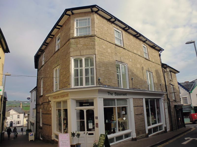
Earlier C19 (shown on 1847 Tithe map) with later alterations.
3- storey snecked rubble structure with 2-window fronts to The Pavement and High Town either side of 1-window splayed corner. Lower 3-storey range continues to N with 1-window to High Town, 1 to rounded corner and 1 3 window front with basement to Lion Street, splayed back following street line. Hipped slate roofs with wide bracket eaves and brick chimney stacks. Various sash windows; marginal glazing bars, keystones and voussoir lintels to S end, small pane (some dummy) with timber lintels to N end; curved windows on the corner with Lion Street. Paired segmental headed casement windows to The Pavement. High Town shop front wraps around the corner with The Pavement; wide cornice and end brackets over panelled pilasters. 4-pane window midway along High Town front is set in a former doorway. Similar shop front wraps around corner with Lion Street; 3-light window to left and 20-pane to right; blocked former corner entrance now with modern window. further entrance in Lion Street; arched headed and with traceried fanlight.
Rubble right gable end with brick chimney stack.
Group value.
External links are from the relevant listing authority and, where applicable, Wikidata. Wikidata IDs may be related buildings as well as this specific building. If you want to add or update a link, you will need to do so by editing the Wikidata entry.


Other nearby listed buildings
