Approximate Location Map
Large Map »
Latitude: 52.5403 / 52°32'24"N
Longitude: -3.0415 / 3°2'29"W
OS Eastings: 329459
OS Northings: 294110
OS Grid: SO294941
Mapcode National: GBR B4.F3VM
Mapcode Global: VH75Q.7DFZ
Plus Code: 9C4RGXR5+49
Entry Name: Hurdley Hall
Listing Date: 26 October 1953
Last Amended: 1 October 1996
Grade: II
Source: Cadw
Source ID: 7704
Building Class: Domestic
ID on this website: 300007704
Location: Isolated house reached down a steep driveway from Hurdley and Lower Hurdley Farms. The house faces N on to a driveway, with a large garden on the other three sides.
County: Powys
Town: Montgomery
Community: Churchstoke (Yr Ystog)
Community: Churchstoke
Locality: Hurdley
Traditional County: Montgomeryshire
Tagged with: House
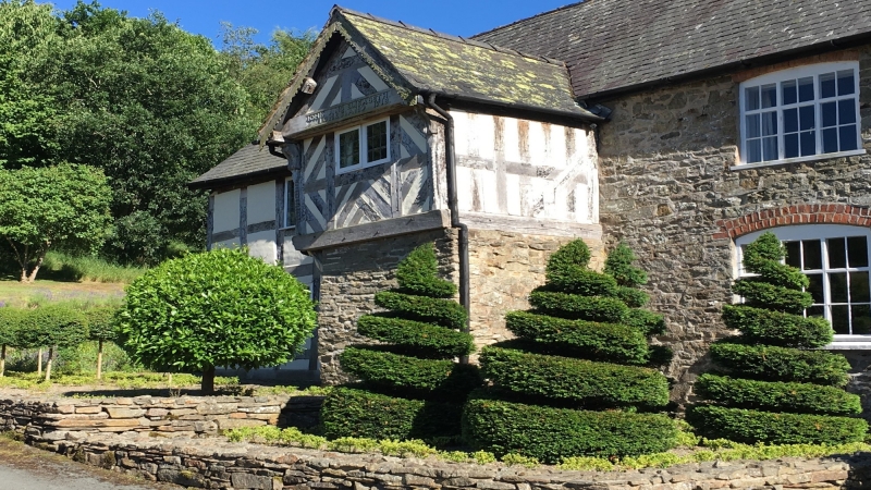
House of c1630, with porch dated 1718, and range to W possibly of later date. Originally box framed with S lateral wall in random rubble, and subsequently part rebuilt in stone.
Two-unit lobby entry house of 2 storeys, with N porch, and a 2-storey extension in stone to W under a lower roof, which has a single-storey lean-to on its gable end. Timber framed in square panels with rendered infill on N and E walls, the remainder in random rubble. Slate roofs, with some stone tiles on the porch. Centrally placed stone stack, and end brick stack on extension to W. In the front, to the left of the porch the building is timber framed, with 2 small C20 casements in earlier openings. To the right of the porch random rubble with 2 small-paned casements under brick segmental heads. In the extension to W is an infilled doorway into a cross-passage, and 2 casement windows. Storeyed porch has a roof of stone tiles on its E slope, slate on its W slope, and notched barge boards. Its upper storey is timber framed, with diagonal braces on E and W sides. Front has chevron struts above sill, and a single casement window. At the angles are thin posts with barley twist under moulded brackets below the tie beam. Tie beam is inscribed 'IOHN AND ELISABETH IONES: ANO 1718'. Lower storey in random rubble on its N and W sides. On E side it is timber framed: flanking the door are moulded brackets under girding beam. At NE angle of the porch the bracket has a carving of a naked male figure, probably a fertility symbol. E side of porch also has a late C20 ledged and battened door. E gable of house is timber framed with diagonal braces at the angles. Gable has a C20 casement, with 2 x C20 casements below it. S wall in random rubble, with outshut in the centre, probably housing stairs originally. The outshut has splayed angles and a single fixed light. A late C20 door is offset from the SE angle of the building, with a 2-light casement to the left of it. To the left of the outshut is a 2-light casement window in the upper storey, and in the lower storey a small-paned casement under a brick segmental head. Extension to W has C20 porch and doorway. In the upper storey it has a 3-light casement window, with a small-paned casement below it. Lean-to is faced in random rubble, with weatherboarding on W side and gable on S side. Part of its original timber framing is visible inside.
First floor of porch is supported on spine and dragon beams with stepped and broach stops. House has back-to-back fireplaces: fireplace in front left room with chamfered bressumer; front right fireplace has a late C19 range. W wall of original house is timber framed, and forms one side of a former through passage in extension to the W, which has a flagstone floor. Cellar beneath the W extension with a single fixed light in the N wall.
Listed as a good example of a C17-C18 lobby entry house of additional special interest for its fine C18 storeyed porch.
External links are from the relevant listing authority and, where applicable, Wikidata. Wikidata IDs may be related buildings as well as this specific building. If you want to add or update a link, you will need to do so by editing the Wikidata entry.


Other nearby listed buildings
