Approximate Location Map
Large Map »
Latitude: 51.5241 / 51°31'26"N
Longitude: -3.5165 / 3°30'59"W
OS Eastings: 294888
OS Northings: 181661
OS Grid: SS948816
Mapcode National: GBR HH.H65L
Mapcode Global: VH5HD.0YBJ
Plus Code: 9C3RGFFM+JC
Entry Name: Dyffryn Farmhouse
Listing Date: 7 November 1991
Last Amended: 4 March 1998
Grade: II
Source: Cadw
Source ID: 11371
Building Class: Domestic
ID on this website: 300011371
Location: Situated at the end of a lane off the S side of Hendre Road, approximately 1km W of the centre of Pencoed. Below the NE side of the M4. The rear (N) of the house faces a courtyard with a further ran
County: Bridgend
Community: Pencoed (Pen-coed)
Community: Pencoed
Locality: Dyffryn
Built-Up Area: Pencoed
Traditional County: Glamorgan
Tagged with: Farmhouse
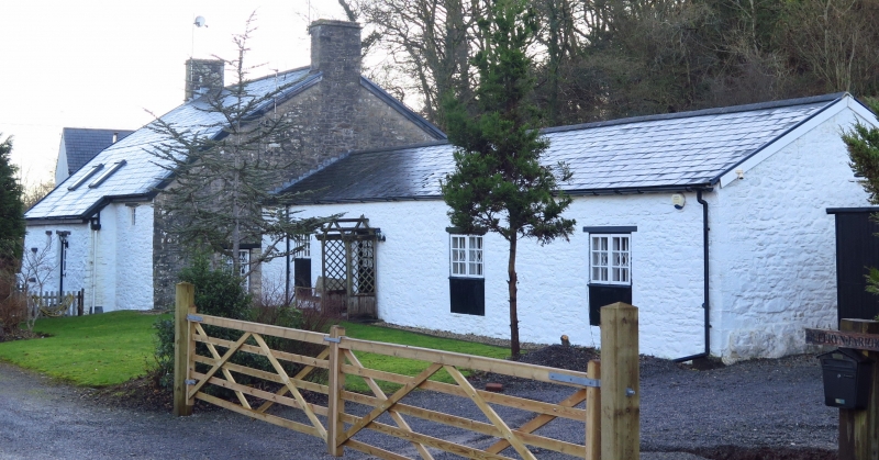
Late C16 origins with C17 alterations and C19 remodelling. The late C16 house was 2- unit with hall and parlour. It was end-entry with fireplace and doorway in the W gable end. In the C17, the house was converted to a lobby entry arrangement with door to the L of the front. The roof was raised at this time, and the outshut was added to the rear to form a service area with new staircase. The house was remodelled in the C19, and new openings were made in the front. Said to have been formerly stone-tiled.
Two storeys and attic; whitewashed rubble under a slate roof with rubble end stacks. Continuous outshut to rear; long adjoining range to W. 2 1 window front (S) with small-pane horizontal sash windows to 1st floor. Planked half-lit door R of centre with small panes, flanked by 16-pane sash window to L, and late C20 casement to R to match the sashes above. Mainly stone sills and timber lintels. There is a blocked doorway to the far L which would have provided a lobby entry in the C17. The outshut has 3 small windows of various styles with timber lintels, and a door as on the front. The E gable end has three 2-light casement windows to the ground floor, and one to the 1st floor. Glazed door to W gable end to rear of adjoining range.
The adjoining, long single-storey range was formerly stables. It is of whitewashed rubble under an asbestos slate roof with skylights to front. The front elevation has 3 pairs of French doors and a small window. The rear has a half lit door and 3 windows with timber fascia below, probably originally stable doors.
No access to interior at time of inspection, but said in 1991 to contain a massive cross beam with deep chamfer; a substantial arched bressumer to the L fireplace with domed bread oven; a late C16 chamfered-arched dressed-stone doorway with diagonal stops to R, which formerly opened onto winding stone stairs; the stairs were subsequently moved to the rear outshut.
Listed as a well preserved Glamorganshire farmhouse of sub-medieval origin, which contains evidence for the changing plans and styles of domestic architecture from the C16 to the C19.
External links are from the relevant listing authority and, where applicable, Wikidata. Wikidata IDs may be related buildings as well as this specific building. If you want to add or update a link, you will need to do so by editing the Wikidata entry.


Other nearby listed buildings
