Latitude: 51.5282 / 51°31'41"N
Longitude: -3.4973 / 3°29'50"W
OS Eastings: 296229
OS Northings: 182091
OS Grid: SS962820
Mapcode National: GBR HH.GYVT
Mapcode Global: VH5HD.BVHC
Plus Code: 9C3RGGH3+73
Entry Name: Church of St David
Listing Date: 4 March 1998
Last Amended: 4 March 1998
Grade: II
Source: Cadw
Source ID: 19478
Building Class: Religious, Ritual and Funerary
Also known as: St David's Church, Pencoed
Church of St. David
ID on this website: 300019478
Location: Located on the W side of Penprysg Road to the N of Pencoed County Junior School. The church is situated in a large plot with car park to the S and graveyard to the rear.
County: Bridgend
Community: Pencoed (Pen-coed)
Community: Pencoed
Built-Up Area: Pencoed
Traditional County: Glamorgan
Tagged with: Church building
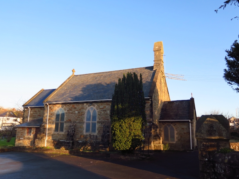
There is some dispute regarding the date and history of the church. However, it is labelled as a church on the 6” Ordnance Survey of 1885, is recorded as a church in 1865 and was possibly built in 1862. It was a chapel of ease to the parish church of Coychurch, but functioned as a school room during the week, before the construction of the Board School on the plot to the S in 1879. It was licensed for services in 1915, for marriages in 1922, and for the consecration of the burial ground in 1924. The doorways in the porch had to be moved to accommodate coffins, and this is supported by physical evidence. If built as a church, it is hard to explain why the chancel is at the W end. It could have been built as a school and then converted to a church.
Small simple Early English-style church consisting of nave, chancel, porch and bellcote. The church is unusual because the chancel is at the W end, with bellcote and porch at the E end. Constructed of roughly coursed red and cream masonry on a plinth and under a slate roof. Stone dressings and raised stone copings to gables. The chancel and S nave have a continuous string course. Angle buttresses to nave and diagonal buttresses to chancel. The pointed-arched windows have transomed Y-tracery and diamond quarries, all under stone heads with voussoirs.
The nave has 3 windows to the S side with buttresses between. There are 2 windows to the N side flanking a small lean-to with a C20 planked door. Set above the lean-to is a truncated masonry stack. (There is now a steel flue in the roof pitch which is covered in asbestos-cement slates.) The bellcote is supported on the E gable of the nave. The chancel is narrower and lower than the nave and is flanked by small lean-tos with hipped roofs. That to the S has a planked door with 4-pane window to left, and that to the N has a boarded window. The W window of the chancel is 3-light.
The porch doorway is at the E end, under a segmental arched head with planked doors. There is a small window to the S. Butt joints can be seen to N and S walls, probably defining blocked doorways with dressed reveals which were in use before the church was licensed for burials.
Simple interior. Narrow pointed chancel arch with chamfers under a hood-mould. The chancel window has stained glass. Simple collar truss roof. Wooden pews in SW corner of nave with moulded arm rests. Small marble memorials to those who died in WWI and WWII. A plaque records that the bellcote was rebuilt in 1989 in memory of Richard David Evans. Scissor-braced roof in porch.
Listed as a small well-preserved Gothic-style church of unusual character, which also functioned as a school.
External links are from the relevant listing authority and, where applicable, Wikidata. Wikidata IDs may be related buildings as well as this specific building. If you want to add or update a link, you will need to do so by editing the Wikidata entry.


Other nearby listed buildings