History in Structure

Milestone, Coychurch Road

A Grade II Listed Building in Pencoed, Bridgend

More Photos »
Approximate Location Map
Large Map »

Coordinates

Latitude: 51.518 / 51°31'4"N

Longitude: -3.504 / 3°30'14"W

OS Eastings: 295741

OS Northings: 180972

OS Grid: SS957809

Mapcode National: GBR HH.HP9Y

Mapcode Global: VH5HL.63YM

Plus Code: 9C3RGF9W+6C

Entry Name: Milestone, Coychurch Road

Listing Date: 4 March 1998

Last Amended: 4 March 1998

Grade: II

Source: Cadw

Source ID: 19477

Building Class: Transport

ID on this website: 300019477

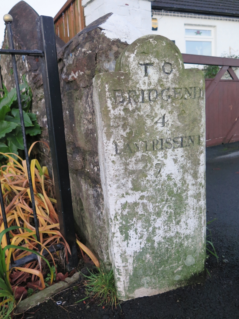
Location: Located on the W side of Coychurch Road (B4280), the main road through Pencoed. The milestone is at the rear of the pavement.

County: Bridgend

Community: Pencoed (Pen-coed)

Community: Pencoed

Built-Up Area: Pencoed

Traditional County: Glamorgan

Tagged with: Milestone

Find accommodation in
Pencoed

History

C18 - C19 milestone connected with the turnpiking of the road between Bridgend and Llantrisant. The road was turnpiked following a parliamentory Act of 1764 and is shown on Yates’ map of 1799. The milestone may have been set back from its original position.

Exterior

Upright rectangular stone with round head. Whitewashed, with chamfered edges and horizontal striations. On its face is the following engraving: TO / BRIDGEND / 4
/ LANTRISSENT / 7.

Reasons for Listing

Listed as a well preserved and detailed milestone dating from the age of turnpike roads.

External Links

External links are from the relevant listing authority and, where applicable, Wikidata. Wikidata IDs may be related buildings as well as this specific building. If you want to add or update a link, you will need to do so by editing the Wikidata entry.

Recommended Books

Other nearby listed buildings

  • II Salem Chapel
    Located on the E side of Coychurch Road, 0.4km S of the village centre. The chapel is fronted by low stone walls supporting decorative iron railings, and stone piers. The vestry is to the N and the g
  • II War Memorial and Railings
    Located in the centre of Pencoed at the junction of Coychurch Road, Hendre Road and Penybont Road. The GWR and crossing are to the W.
  • II Cowshed at Pantruthin-fach Farm
    Immediately north of the farmhouse across the yard.
  • II Pantruthin-fach Farmhouse
    Right on the northen edge of Llangan Community hard against the M4.
  • II Dyffryn Farmhouse
    Situated at the end of a lane off the S side of Hendre Road, approximately 1km W of the centre of Pencoed. Below the NE side of the M4. The rear (N) of the house faces a courtyard with a further ran
  • II Church of St David
    Located on the W side of Penprysg Road to the N of Pencoed County Junior School. The church is situated in a large plot with car park to the S and graveyard to the rear.
  • II Bridge over Afon Ewenni
    Located off the S side of Penybont Road (B4280), W of a large roundabout at Tregroes, and 0.7km NE of Pencoed. The bridge carries a narrow track to the rear of dwellings along Penybont Road.
  • II Bridge at Tregroes
    Located on the driveway leading to Tregroes House, just before the drive forms a circle in front of the house. The bridge crosses a small pool or stream which is currently dry.

BritishListedBuildings.co.uk is an independent online resource and is not associated with any government department. All government data published here is used under licence. Please do not contact BritishListedBuildings.co.uk for any queries related to any individual listed building, planning permission related to listed buildings or the listing process itself.

British Listed Buildings is a Good Stuff website.