Approximate Location Map
Large Map »
Latitude: 51.6163 / 51°36'58"N
Longitude: -4.239 / 4°14'20"W
OS Eastings: 245080
OS Northings: 193210
OS Grid: SS450932
Mapcode National: GBR GR.15X0
Mapcode Global: VH3MP.GMVS
Plus Code: 9C3QJQ86+G9
Entry Name: Glebe Farmhouse
Listing Date: 3 June 1964
Last Amended: 3 March 2000
Grade: II
Source: Cadw
Source ID: 11522
Building Class: Domestic
ID on this website: 300011522
Location: At west side of road, immediately north of St Cadoc's Church in Cheriton.
County: Swansea
Town: Swansea
Community: Llangennith, Llanmadoc and Cheriton (Llangynydd, Llanmadog a Cheriton)
Community: Llangennith, Llanmadoc and Cheriton
Locality: Cheriton
Traditional County: Glamorgan
Tagged with: Farmhouse
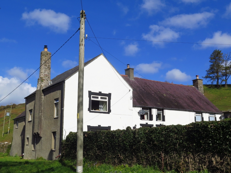
Glebe Farmhouse, possibly built in the C14, and said to be the oldest inhabited building in Gower, was probably established as a centre for the Knights Hospitallers who owned extensive estates locally including Cheriton and Landimore. Later it was the Cheriton parsonage and since the mid-C18 it has been a farmhouse (with a farm stated in 1846 to be of 60 acres(24.3 hectares)).
The building has a hall range and a solar range. There is evidence also for a cross passage and there are likely to have been service rooms at the north end of the hall. The solar range lies east/west at right angles to the hall range and against the boundary with the churchyard. Its upper chimney, corbelled out on the exterior, is a local landmark.
The house was late to be converted to storeyed form. The hall was still said to be open to the roof in 1720 and the ceiling below the roof was not inserted until after 1860. Additional stairs and three chimneys were inserted in the hall range; the chimney at the north gable has two bread-ovens, now concealed.
The hall and solar ranges meet as a T; the latter has a later extension west which then adjoins farm buildings, the grouping enclosing a sunken domestic yard. This yard is segregated from the farm access road by a retaining wall and steps.
The north/south hall range is of stone, rendered and whitened, with slate roof and tile ridge; in the elevation facing the road there are four windows above and three windows plus two doors below, all modern frames. Small mid-chimney, large end-chimney at north gable with the exterior projections of two bread ovens.
The east/west former solar range has higher eaves; rendered, whitened except to the south. All fenestration modernised. At the centre of the south elevation is a large chimney standing on three moulded corbels at first floor level, reducing in size slightly at eaves level, and changing from square to octagonal shape about a metre above eaves; the octagonal part is about three metres tall. Roughly repaired at top and carrying a modern chimneypot.
The original five-bay roof structure of the hall range is smoke-blackened. This is a remarkable mediaeval survival with cambered and chamfered high collars and decorative carved features on the exposed ends of the principals.
The internal hood of the mediaeval solar fireplace in the south wall also survives, with a bressummer on two billet corbels with a small candle-shelf each side.
A mediaeval stone staircase in an outshut on the west side links the former solar to the end of the former hall. The stairs enclosure has stone archways and a stone ceiling parallel to the plane of the stairs.
An important mediaeval house retaining its original hall roof, outshut-stairs and a fine solar chimney.
External links are from the relevant listing authority and, where applicable, Wikidata. Wikidata IDs may be related buildings as well as this specific building. If you want to add or update a link, you will need to do so by editing the Wikidata entry.


Other nearby listed buildings
