Approximate Location Map
Large Map »
Latitude: 52.0235 / 52°1'24"N
Longitude: -4.8947 / 4°53'40"W
OS Eastings: 201493
OS Northings: 240078
OS Grid: SN014400
Mapcode National: GBR CP.GLL3
Mapcode Global: VH1QH.3DQM
Plus Code: 9C4Q24F4+C4
Entry Name: Ruins of Old Church of a St Brynach
Listing Date: 16 January 1952
Last Amended: 17 November 1994
Grade: II
Source: Cadw
Source ID: 11977
Building Class: Religious, Ritual and Funerary
ID on this website: 300011977
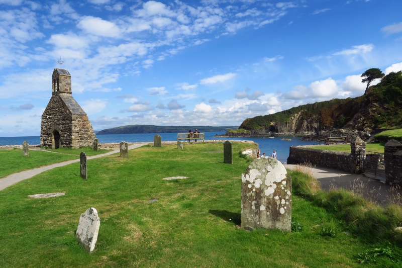
Location: Situated overlooking bay on SE side of Dinas Island.
County: Pembrokeshire
Community: Dinas Cross (Dinas)
Community: Dinas Cross
Locality: Cwm-Yr-Eglwys
Traditional County: Pembrokeshire
Tagged with: Church ruin
The medieval church of St Brynach was said to have replaced one at Brynhellan. It had nave, chancel, S transept and W bellcote according to mid C19 engraving: the surviving detail looks C15. It was severely damaged by storms in 1851 and destroyed in the great storm of 25 October 1859, leaving only the W gable. It was not rebuilt, but replaced by the present church of St Brynach at Brynhenllan, 1860-1 by R K Penson.
Rubble stone low W wall and bellcote. Low Tudor-arched doorway with rough chamfered jambs and head in similar grey stone to C15 barn at Pentre Ifan, Nevern. Low pitched gable, coped in slates. Bellcote has 2 Tudor-arched chamfered openings in similar stone and slates to gable coping. Inner door head and rough stone voussoirs to cambered head.
External links are from the relevant listing authority and, where applicable, Wikidata. Wikidata IDs may be related buildings as well as this specific building. If you want to add or update a link, you will need to do so by editing the Wikidata entry.


Other nearby listed buildings
