History in Structure

The Old Printing House

A Grade II Listed Building in Solva, Pembrokeshire

More Photos »
Approximate Location Map
Large Map »

Coordinates

Latitude: 51.875 / 51°52'30"N

Longitude: -5.1887 / 5°11'19"W

OS Eastings: 180604

OS Northings: 224413

OS Grid: SM806244

Mapcode National: GBR C8.S5N1

Mapcode Global: VH1R3.04TF

Plus Code: 9C3PVRG6+2G

Entry Name: The Old Printing House

Listing Date: 4 February 1991

Last Amended: 4 February 1991

Grade: II

Source: Cadw

Source ID: 12447

Building Class: Domestic

ID on this website: 300012447

Location: Situated on northern side opposite The Ship Inn.

County: Pembrokeshire

Community: Solva (Solfach)

Community: Solva

Locality: Solfach Isaf/Lower Solva

Traditional County: Pembrokeshire

Tagged with: House Printery

Find accommodation in
Solva

Exterior

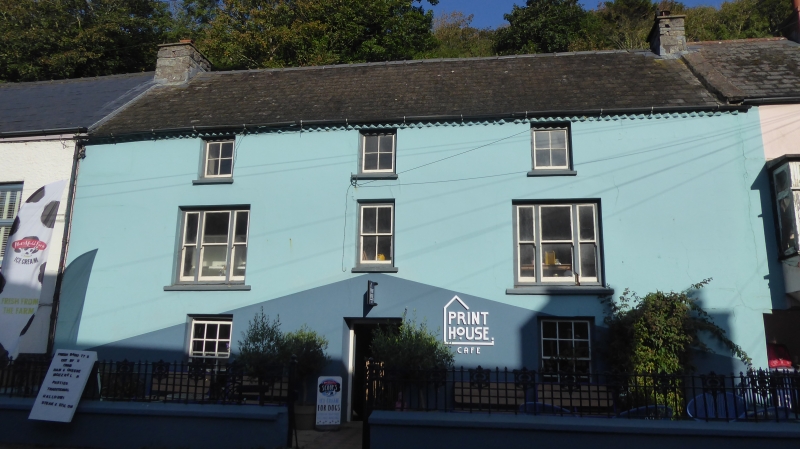
Later C18 or early C19 substantial house in colourwashed render with nogged brick eaves, medium-pitch slate roof and short stone end stacks. Long 3-storey, 3-window front. Twelve-pane sashes each side of centre door with wood-panelled reveals and moulded wood cornice. First floor centre 4-pane sash, the outer windows lengthened and widened in C20 for tripartite 2-4-2 pane sashes. Four-pane upper windows. Slat sills. Front garden is enclosed by rendered, coped low wall with C1900 Art Nouveau cast-iron low rails and gate. A one-window extension to right is built over through carriageway. First floor large square oriel on rendered base. Slate roof and brick end stack.

Reasons for Listing

Marked on 1836 sale map of Lower Solva (Pembs. Rec. Office DB/16/131) as dwelling house occupied by Lt John Richards. In 1861 John Williams founded The Dewisland and kemes Guardian here; later The Pembroke County Guardian, later The West Wales Guardian. Offices were in Solva 1861-1906.

Group value with other listed items in Main Street.

External Links

External links are from the relevant listing authority and, where applicable, Wikidata. Wikidata IDs may be related buildings as well as this specific building. If you want to add or update a link, you will need to do so by editing the Wikidata entry.

Recommended Books

Other nearby listed buildings

  • II Gwyryd House
    Situated towards western end of street, the last house in the continuous terrace.
  • II The Hungry Caterpillar Cafe & Shop
    Situated gable-end to street line adjoining No 10 (Tan-yr-Allt).
  • II Tan-Yr-Allt
    Detached house on northern side, set back on high terrace between former warehouse and former Calvinistic Methodist Chapel.
  • II Limekiln adjacent to Brookside
    Situated on eastern side of footpath beyond children’s playground.
  • II The Cambrian Inn
    Situated opposite Solva Bridge at NE end of Main Street.
  • II Solva Bridge
    Situated at northern end of Main Street (A487) where it crosses the River Solva.
  • II Limekiln adjacent to the Smithy
    Situated on eastern side of Y Gribin about 6m from junction with main road.
  • II Glennydd
    Detached house about mid-way down the range of houses, some 200m east of Cambrian Inn.

BritishListedBuildings.co.uk is an independent online resource and is not associated with any government department. All government data published here is used under licence. Please do not contact BritishListedBuildings.co.uk for any queries related to any individual listed building, planning permission related to listed buildings or the listing process itself.

British Listed Buildings is a Good Stuff website.