Approximate Location Map
Large Map »
Latitude: 51.8773 / 51°52'38"N
Longitude: -5.1867 / 5°11'12"W
OS Eastings: 180751
OS Northings: 224660
OS Grid: SM807246
Mapcode National: GBR C9.RS5Y
Mapcode Global: VH1R3.12VP
Plus Code: 9C3PVRG7+W8
Entry Name: Glennydd
Listing Date: 4 February 1991
Last Amended: 4 February 1991
Grade: II
Source: Cadw
Source ID: 12449
Building Class: Domestic
ID on this website: 300012449
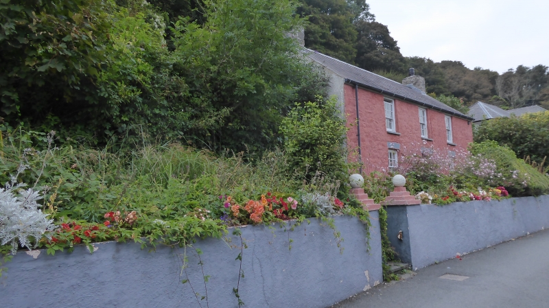
Location: Detached house about mid-way down the range of houses, some 200m east of Cambrian Inn.
County: Pembrokeshire
Community: Solva (Solfach)
Community: Solva
Locality: Solfach Isaf/Lower Solva
Traditional County: Pembrokeshire
Tagged with: Building
Early C19 small house, colourwashed rubble stone with slate roof and rendered end stacks. Two-storey, three-window range of 12-pane sashes with slate sills. Centre door. Painted brick heads to ground floor openings. Rendered end walls. Front garden enclosed by colourwashed rubble embanking wall.
Deeds said to go back to 1807. Marked on 1838 Tithe Map.
External links are from the relevant listing authority and, where applicable, Wikidata. Wikidata IDs may be related buildings as well as this specific building. If you want to add or update a link, you will need to do so by editing the Wikidata entry.


Other nearby listed buildings
