Latitude: 51.4097 / 51°24'34"N
Longitude: -3.4882 / 3°29'17"W
OS Eastings: 296590
OS Northings: 168904
OS Grid: SS965689
Mapcode National: GBR HJ.QF90
Mapcode Global: VH5HZ.HT8P
Plus Code: 9C3RCG56+VP
Entry Name: Swimbridge Farmhouse with attached garden walls
Listing Date: 10 September 1982
Last Amended: 16 December 2004
Grade: II
Source: Cadw
Source ID: 13282
Building Class: Domestic
ID on this website: 300013282
Location: About 200m north of the Church of St. Illtud.
County: Vale of Glamorgan
Town: Cowbridge / Y Bont-Faen
Community: Llantwit Major (Llanilltud Fawr)
Community: Llantwit Major
Built-Up Area: Llantwit Major
Traditional County: Glamorgan
Tagged with: Farmhouse
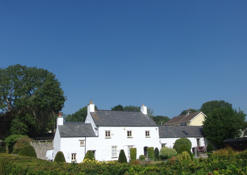
c1600 original gable entry two unit house, remodelled externally and with a west addition 1812 (although there was an earlier addition with a higher roof-line); later alterations in both the mid C20 and late C20 since listing in 1982 and all the joinery dates from then.
Probably local rubblestone walls with roughcast cladding. Welsh slate gabled roof with rendered stone flanking stacks. Two storey single depth plan farmhouse with lower two storey wing to left and single storey one to right, both in line. Upper and ground floor openings not in alignment. On ground floor, two sash windows two
panes wide with horns, with a late C20 doorway with trellis porch to right; three 2-light wood casements on first floor. C17 type plank doors.
Lower south-west service wing with 2-light window with small panes to left hand below, similar loft window in middle and wooden boarded door to right hand. Adjoining north-east outbuilding with gabled slate roof and whitewashed stone rubble walls, late C20 windows. Rear elevation with two storey wing and similar windows.
Garden to south-east of house enclosed by stone rubble walls on south-east and south-west, the south-east wall with roughly rounded stone coping, serving as a north retaining wall along the Ogney Brook. The south-west garden wall with various stone copings; C19 iron gate towards northern end with circular
uprights with arrowheaded finials rising alternately above top and middle rails. From north-west of gate, wall returns to service wing.
South-west room with three stopped and chamfered beams, arched, stopped and chamfered doorway to stone fireplace stair which has a corbelled roof. The fireplace has been revealed since listing in 1982. It has chamfered stone jambs
though with differing stops, and an oak lintel. The house has the rare feature of a stone wall dividing the hall and the inner room, rising through both floors. The present main door now enters the inner room. The south-west extension retains a bread oven with iron door.
Included as a late C16 to C17 house which, despite changes, retains both character and features of special interest.
External links are from the relevant listing authority and, where applicable, Wikidata. Wikidata IDs may be related buildings as well as this specific building. If you want to add or update a link, you will need to do so by editing the Wikidata entry.


Other nearby listed buildings