Approximate Location Map
Large Map »
Latitude: 51.4742 / 51°28'27"N
Longitude: -3.4791 / 3°28'44"W
OS Eastings: 297370
OS Northings: 176064
OS Grid: SS973760
Mapcode National: GBR HJ.L9MK
Mapcode Global: VH5HS.N63Q
Plus Code: 9C3RFGFC+M9
Entry Name: Penllyn Cottage
Listing Date: 7 April 1989
Last Amended: 30 April 2004
Grade: II
Source: Cadw
Source ID: 13434
Building Class: Domestic
ID on this website: 300013434
Location: At the south end of the village, at right angles to Lodge Cottage and opposite the church. Facing the main drive to Penllyn Castle.
County: Vale of Glamorgan
Town: Cowbridge
Community: Penllyn (Pen-llin)
Community: Penllyn
Traditional County: Glamorgan
Tagged with: Cottage
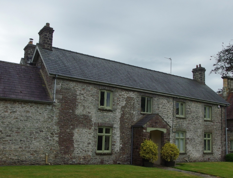
Probably later C18 with mid to late C19 alterations including heightening. Works may coincide with the two main building periods of Penllyn Castle (qv). It is shown on the tithe map of 1839.
Roughly squared local limestone rubble front with Welsh slate roof and rubble end chimney stacks. Two storey, 4-bay double depth plan in two parallel ranges. Timber casement windows with lightly cambered voussoirs, 2-light to first floor and cross-frame below. Gabled porch to second bay with Tudor pointed arch opening, boarded door. There may be a blocked up opening to left, there are indications of disturbance in the front stonework which may suggest a complete re-windowing. Lower outbuilding range (now garage) to left with small pane casement window to the gable end. Linked to Lodge Cottage at right by a low, narrow range. Modernised at rear (not seen at resurvey).
Interior not available at resurvey.
Included for its special interest as part of a group of well designed estate buildings at the entrance to Penllyn Castle.
External links are from the relevant listing authority and, where applicable, Wikidata. Wikidata IDs may be related buildings as well as this specific building. If you want to add or update a link, you will need to do so by editing the Wikidata entry.


Other nearby listed buildings
