History in Structure

Milestone

A Grade II Listed Building in Caerphilly (Caerffili), Caerphilly

More Photos »
Approximate Location Map
Large Map »

Coordinates

Latitude: 51.5678 / 51°34'4"N

Longitude: -3.2165 / 3°12'59"W

OS Eastings: 315782

OS Northings: 186139

OS Grid: ST157861

Mapcode National: GBR HW.DHN2

Mapcode Global: VH6DT.6VFH

Plus Code: 9C3RHQ9M+4C

Entry Name: Milestone

Listing Date: 19 March 1975

Last Amended: 18 February 1999

Grade: II

Source: Cadw

Source ID: 13553

Building Class: Transport

ID on this website: 300013553

Location: Located outside the Coach House Gallery to the S of Warren Drive.

County: Caerphilly

Town: Caerphilly

Community: Caerphilly (Caerffili)

Community: Caerphilly

Locality: Caerphilly Centre

Built-Up Area: Caerphilly

Traditional County: Glamorgan

Tagged with: Milestone

Find accommodation in
Caerphilly

History

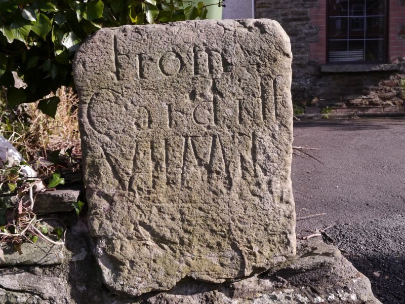
Probably C18, representing the turnpiking of an ancient route from Caerphilly to Cardiff. Now incorporated in a snecked stone wall, so probably not in its original position.

Exterior

Limestone block, tapering out towards the top and roughly rectangular in plan. An inscription on the front face reads 'From / Cardiff / VII Mile'. Now incorporated in a garden wall of snecked stone as an end pier.

Reasons for Listing

Listed for its historic interest as a feature of the former turnpike road.

External Links

External links are from the relevant listing authority and, where applicable, Wikidata. Wikidata IDs may be related buildings as well as this specific building. If you want to add or update a link, you will need to do so by editing the Wikidata entry.

Recommended Books

Other nearby listed buildings

  • II Church of St Martin
    Located on the S side of Caerphilly town at the junction of Mountain Road and St Martins Road, just N of the railway station.
  • II Van Road United Reformed Church
    On corner with Goodrich Street.
  • II Twyn County Junior School
    Located in the angle of East View and Southern Street. Surrounded by the playground, with the infants school of 1906 immediately to the W.
  • II The Court House
    Set back from Cardiff Road on a sharp bend. Town centre position overlooking S lake to Caerphilly Castle at rear.
  • II Wesley Methodist Church
    Located at the junction of Crescent Road and St Fagan's Street, just W of the town centre. Set into the slope with elevated entry over basement area.
  • II Memorial to David Williams
    In the park overlooking the lake immediately S of Caerphilly Castle.
  • II War Memorial
    In a prominent position opposite Caerphilly Castle, at the junction of Castle Street and Market Street.
  • II Plas Watford
    Set back from the road as it climbs up towards Caerphilly Mountain. Opposite Watford Fach Farmhouse.

BritishListedBuildings.co.uk is an independent online resource and is not associated with any government department. All government data published here is used under licence. Please do not contact BritishListedBuildings.co.uk for any queries related to any individual listed building, planning permission related to listed buildings or the listing process itself.

British Listed Buildings is a Good Stuff website.