History in Structure

The Cross

A Grade II Listed Building in Dinas Cross, Pembrokeshire

More Photos »
Approximate Location Map
Large Map »

Coordinates

Latitude: 52.0122 / 52°0'43"N

Longitude: -4.8889 / 4°53'20"W

OS Eastings: 201839

OS Northings: 238804

OS Grid: SN018388

Mapcode National: GBR CP.HG01

Mapcode Global: VH1QH.6PS9

Plus Code: 9C4Q2466+VC

Entry Name: The Cross

Listing Date: 17 November 1994

Last Amended: 17 November 1994

Grade: II

Source: Cadw

Source ID: 14937

Building Class: Domestic

ID on this website: 300014937

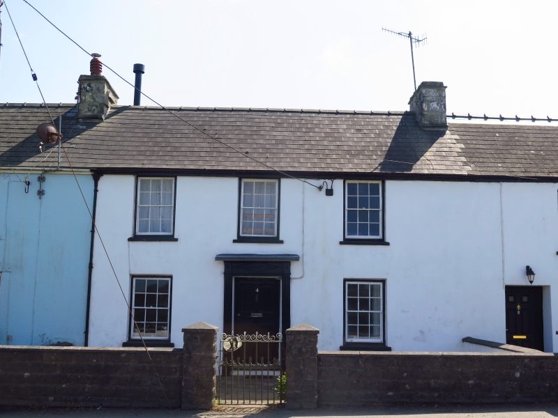
Location: Situated in short terrace of five, some 100m W of Gedeon Chapel.

County: Pembrokeshire

Community: Dinas Cross (Dinas)

Community: Dinas Cross

Traditional County: Pembrokeshire

Tagged with: Building

Find accommodation in
Dinas

Exterior

Earlier C19 terrace house, painted stucco with imitation slate roof and stone end stacks. Teo-storey, three-window range of hornless 12-pane sashes and centre door. Five-panel door in moulded timber doorcase, reeded piers, entablature with lozenge panel over door and raised blocks over piers, shelf hood. Painted slate sills.

Reasons for Listing

Included as good example of earlier C19 terrace house, still with original windows, door and doorcase.

External Links

External links are from the relevant listing authority and, where applicable, Wikidata. Wikidata IDs may be related buildings as well as this specific building. If you want to add or update a link, you will need to do so by editing the Wikidata entry.

Recommended Books

Other nearby listed buildings

  • II Gedeon Independent Chapel
    Situated on bank above main road, facing W, opposite land Cwm-yr-Eglwys.
  • II Tanybryn
    Situated on E side of lane from Dinas Cross to Cwym-yr-Eglwys, some 0.5km N of Dinas Cross.
  • II Glanymor
    Situated on roadside, some 400m E of Gedeon Chapel.
  • II Castle Green including Front Railings
    Situated in third terraced row from E, between Trefonnen and 2 Castle Green.
  • II Ty Cambria
    Situated on road to Brynhenllan, some 100m N of 487.
  • II Pont Felinwerndew (partly in Newport Community)
    Situated on boundary of Dinas and Newport communities, below modern road embankment by Felin Werndew.
  • II Pont Felin-Wern-Dew
    Situated on boundary of Newport and Dinas communities, over Nant Fforest, and immediately S of modern A487 embankment.
  • II Limekiln on Aberfforest Beach
    Situated by beach some 150m N of Fforest farm, which is approached by long track running N off A487 Fishguard road near boundary with Dinas community.

BritishListedBuildings.co.uk is an independent online resource and is not associated with any government department. All government data published here is used under licence. Please do not contact BritishListedBuildings.co.uk for any queries related to any individual listed building, planning permission related to listed buildings or the listing process itself.

British Listed Buildings is a Good Stuff website.