Approximate Location Map
Large Map »
Latitude: 52.9801 / 52°58'48"N
Longitude: -3.4305 / 3°25'49"W
OS Eastings: 304052
OS Northings: 343488
OS Grid: SJ040434
Mapcode National: GBR 6M.J760
Mapcode Global: WH780.8CP6
Plus Code: 9C4RXHJ9+2R
Entry Name: The Druids
Listing Date: 1 February 1995
Last Amended: 1 February 1995
Grade: II
Source: Cadw
Source ID: 15547
Building Class: Commercial
ID on this website: 300015547
Location: At the junction of the A5 with the Bala Road.
County: Denbighshire
Community: Corwen
Community: Corwen
Locality: Druid
Traditional County: Merionethshire
Tagged with: Architectural structure
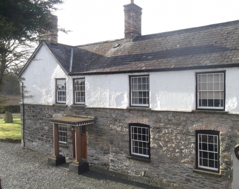
Originally a farmhouse, and used at some time as an inn, with parts also apparently used as a butchers' shop, and a smithy; now a private house. The house has been developed in a number of phases, the earliest of which may be incorporated in what is now the W wing. The main range facing E was probably added to this in the late C18, but a major remodelling of the house seems to have taken place c1850, in which the W wing was raised in height, refenestrated, and probably extended by the addition of a wing and 2 parallel gables to the S. the main range was also refenestrated at the same time. To the S, a range of former outbuildings (possibly associated with the use of the premises at one time as a smithy) have since been incorporated into the house. The house was again thoroughly remodelled internally in c1950, and although the original layout was retained, many of the interior fittings were introduced at this time.
W wing may represent the earliest part of the building, though raised to two full storeys in the C19. The main range faces E, with a short rear wing to its N linking it with the older W wing, and containing the main entrance, and stair hall. 3-window E elevation, and angled S wing set back. Rough rubble, mainly rendered over, with slate roofs. W wing built in 2 phases, with a 2-window range adjoining the later main range of the house. Former doorway to the right, and 2 windows on each floor - 12-pane sashes with margin lights. 16-pane sash window on each floor in the separate right hand section. Main entrance is in porch with marble columns and modillion timber cornice (probably an addition of c1950), in the short rear wing of the main range. 8-pane sash window with margin lights above the doorway. Garden front (facing E) is a 3-window range, with margin-light sashes on each floor. Verandah with fluted cast iron columns and scrolled brackets was probably added in the C20. Parallel range set back to the rear forms a rear wing of the earlier W wing, and 2 shorter parallel gables project from the W wing: these also have 12-pane sashes with margin lights, with some later openings. A balcony giving access to an upper doorway was added c1950.
Lower wing to S may have originated as outbuildings. A long 2-window range with doorway towards right in E elevation; N elevation has central doorway and iron lattice-glazing to right hand window and in gabled dormers.
The W wing has a massive lateral chimney which may be indicative of an early date for this part of the building. Most of the internal joinery and other fittings including fireplaces are not in situ.
The architectural quality of the house is largely defined by its C19 remodelling, but the earlier origins of the building, together with its one-time use as a road-side inn, appear to have shaped the planning of the building and have resulted in a complex layout and sequence of development which are also of special interest.
External links are from the relevant listing authority and, where applicable, Wikidata. Wikidata IDs may be related buildings as well as this specific building. If you want to add or update a link, you will need to do so by editing the Wikidata entry.


Other nearby listed buildings
