Latitude: 53.0884 / 53°5'18"N
Longitude: -3.0224 / 3°1'20"W
OS Eastings: 331623
OS Northings: 355062
OS Grid: SJ316550
Mapcode National: GBR 74.9JB7
Mapcode Global: WH88R.JMZR
Plus Code: 9C5R3XQH+92
Entry Name: Former Llay Hall Colliery Washery Building
Listing Date: 26 September 1994
Last Amended: 1 December 1995
Grade: II
Source: Cadw
Source ID: 15828
Building Class: Industrial
ID on this website: 300015828
Location: Located in the group of former Llay Hall Colliery buildings in use as an industrial estate east of Mold Road. The former washery is a large building converted to industrial workshops at the south-east
County: Wrexham
Community: Gwersyllt
Community: Gwersyllt
Locality: Sydallt
Built-Up Area: Sydallt
Traditional County: Denbighshire
Tagged with: Architectural structure
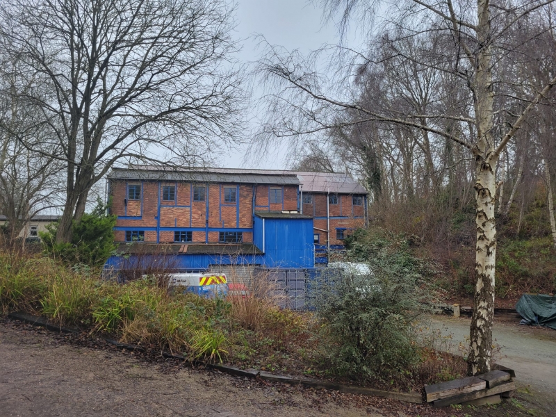
Llay Hall Colliery operated from 1877 until 1948. It was sunk by the Llay Hall Coal, Iron and Fireclay Company and worked in association with a fire brick works on the opposite side of the River Alyn. It was nationalised in 1947 but closed shortly afterwards, following a serious underground explosion. The screens and washery building was built around 1920. It formerly contained equipment for sorting and washing coal, but was converted to a regional stores building by the National Coal Board c1948 and subsequently used as a mail-order warehouse and then a light engineering plant. Washery buildings were characteristic of the coal industry in the twentieth century. They were introduced in the 1880s and used at larger collieries from c1900, but did not become universal until after World War II.
The building is of the typical and highly characteristic construction of early washeries, consisting of brick panels supported on a bolted and riveted steel frame exposed to the facade. The framed construction supported vibrating machinery and permitted flexible internal use. There are square-headed metal framed windows, some inserted during conversion. The building is of an irregular form, with rail and conveyor access, and varying numbers of storeys, built into sloping ground. The overall plan is an oblong aligned north-west to south-east. At the north-west end is a two-storey section with a gable facing the front. To the south-east is a four-storey block with two transverse gables, one larger and higher than the other. On the north-east side of this section, the building extends over a former rail line for hopper loading. A rare surviving section of covered conveyor route, with a concrete ramp and steel frame supporting a segmental roof, slopes to ground level at the northern corner of the building. Inside, the building has been divided into workshops, stores and offices.
Listed as a rare washery building, thought to be one of only two pre-war examples of these distinctive and
important colliery structures surviving in Wales. It has group value with other adjacent colliery buildings.
External links are from the relevant listing authority and, where applicable, Wikidata. Wikidata IDs may be related buildings as well as this specific building. If you want to add or update a link, you will need to do so by editing the Wikidata entry.


Other nearby listed buildings