History in Structure

Single Kiln

A Grade II Listed Building in Penally, Pembrokeshire

More Photos »
Approximate Location Map
Large Map »

Coordinates

Latitude: 51.6685 / 51°40'6"N

Longitude: -4.7229 / 4°43'22"W

OS Eastings: 211798

OS Northings: 200149

OS Grid: SN117001

Mapcode National: GBR GD.RXWV

Mapcode Global: VH2PS.3B08

Plus Code: 9C3QM79G+CR

Entry Name: Single Kiln

Listing Date: 26 April 1996

Last Amended: 26 April 1996

Grade: II

Source: Cadw

Source ID: 16917

Building Class: Industrial

ID on this website: 300016917

Location: At the entrance to Kiln Park caravan site, at the N side close to the filling station, on the E side of the A4139. The kiln is related to the extensive Black Rock quarries at its rear.

County: Pembrokeshire

Community: Penally (Penalun)

Community: Penally

Locality: Kiln Park

Built-Up Area: Penally

Traditional County: Pembrokeshire

Tagged with: Architectural structure

Find accommodation in
Tenby

Exterior

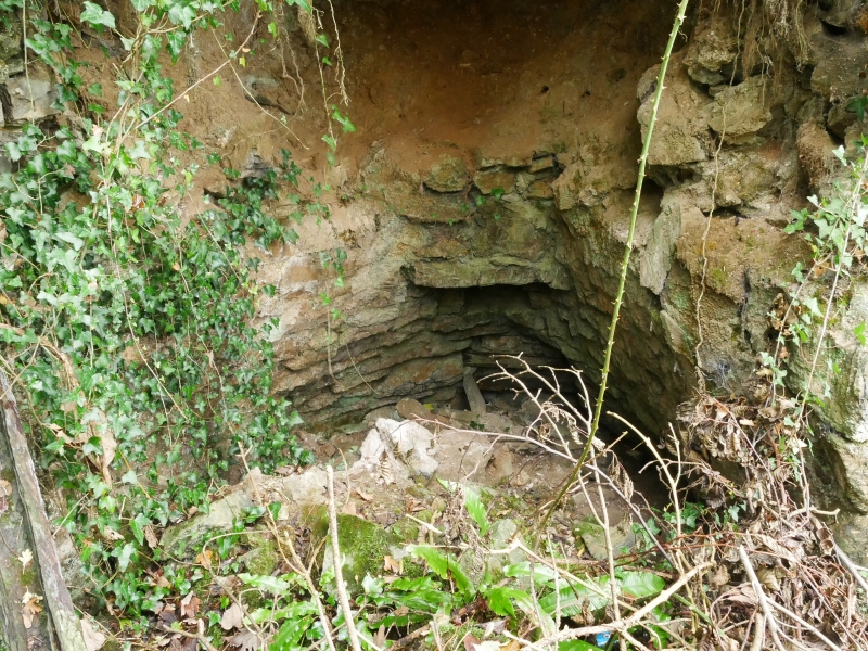
History: This kiln is the survivor of two marked here on the Tithe Map of 1841.

Description: A single limekiln built against the N side of a small quarry face, with working openings at E and W. Approximately semi-circular in plan, with a small low buttress at the N. Brick-lined. Partially collapsed at E. Internal diameter about 3 m.

Listed as an intact example of a limekiln surviving from the early period of the important lime-burning industry at the Black Rock quarries, and for group value with the other kilns on what is now known as Kiln Park.


Reference: Tithe Survey of Penally (1841).

External Links

External links are from the relevant listing authority and, where applicable, Wikidata. Wikidata IDs may be related buildings as well as this specific building. If you want to add or update a link, you will need to do so by editing the Wikidata entry.

Recommended Books

Other nearby listed buildings

  • II* West Set of Kilns
    At the S side of the main private road entering the Kiln Park caravan site, on the E side of the A4139. They are related to the extensive Black Rock quarries at their rear.
  • II The Paddock Inn
    Located at the N end of Penally village, at the E of the main village street. At the front of the site is a paved forecourt with a rendered wall and gate piers.
  • II East Set of Kilns
    At the S side of the main private road entering the Kiln Park caravan site, on the E side of the A4139. These kilns lie 250 m further E than the main set. They are related to the extensive Black Rock
  • II The Watch Tower
    On the summit of the Black Rock promontory overlooking the Ritec. The view from the tower is now obscured by trees.
  • II Milestone outside Springfield
    Situated on the N side of Marsh Road against the garden wall of Springfield some 30m E of Churchill Close.
  • II Old Vicarage
    300 m N of Penally Church, at the W side of the main street of the village.
  • II Heywood Mount
    Set in its own grounds on the S side of Heywood Lane some 250m E of Clickett Lane.
  • II Broadmead
    Set in its own grounds on the S side of Heywood Lane some 300m E of Clickett Lane.

BritishListedBuildings.co.uk is an independent online resource and is not associated with any government department. All government data published here is used under licence. Please do not contact BritishListedBuildings.co.uk for any queries related to any individual listed building, planning permission related to listed buildings or the listing process itself.

British Listed Buildings is a Good Stuff website.