Approximate Location Map
Large Map »
Latitude: 51.6684 / 51°40'6"N
Longitude: -4.7164 / 4°42'59"W
OS Eastings: 212250
OS Northings: 200124
OS Grid: SN122001
Mapcode National: GBR GD.RZWW
Mapcode Global: VH2PS.6BH9
Plus Code: 9C3QM79M+9C
Entry Name: East Set of Kilns
Listing Date: 26 April 1996
Last Amended: 26 April 1996
Grade: II
Source: Cadw
Source ID: 16919
Building Class: Industrial
ID on this website: 300016919
Location: At the S side of the main private road entering the Kiln Park caravan site, on the E side of the A4139. These kilns lie 250 m further E than the main set. They are related to the extensive Black Rock
County: Pembrokeshire
Community: Penally (Penalun)
Community: Penally
Locality: Kiln Park
Built-Up Area: Tenby
Traditional County: Pembrokeshire
Tagged with: Architectural structure
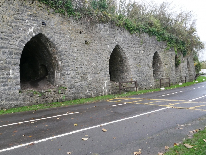
History: Probably contemporary with the main set of kilns, although of simpler layout. They are similarly served with railways sidings both in front and at the rear, but not under cover, and with a crane at the rear.
Description: A set of six large limekilns built in hammer-dressed limestone with rounded corners to the whole block and a slight batter to the main walls. The structure is built against an old quarry-face, facing N. They are in a row with single access spaces between, forming a compact group. The access spaces are steeply vaulted. Each kiln has two working openings, one at E and one at W. The kilns are partially collapsed at the working openings and now visible internally. The interior is about 4 m diameter and is lined in firebricks in header bond.
Listed as multiple limekilns of the railway era (post 1863) and for group value with the other kilns at Kiln Park.
Part of Ancient Monument No. Pe 436
External links are from the relevant listing authority and, where applicable, Wikidata. Wikidata IDs may be related buildings as well as this specific building. If you want to add or update a link, you will need to do so by editing the Wikidata entry.


Other nearby listed buildings
